Photogram
Latest photos of Iran by Bahram Abedini
Photogram
Photogram
Latest photos by Bahram Abedini
Latest photos of Iran by Bahram Abedini
Website Language

")
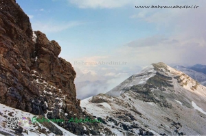
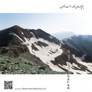
قله ریزان در البرز مرکزی بخش لواسانات، نزدیکی روستای افجه قرار دارد. ارتفاع این قله 3700 متر از سطح دریا می باشد.این عکس از روی خط الراس آتشکوه گرفته شده است. برای رسیدن به این قله می توانید از دو مسیرِ دشت هویج و دشت گردو استفاده کنید. از روی قله ریزان می توان دشت لار و هم چنین قله دماوند را مشاهده کرد. از کوه های اطراف این قله می توان به سیاه چالِ یک و دو وسه،اَندَر، پُرسون، آتشکوه، مهرچال، و پیرزن گلون اشاره کرد. هم چنین آبشار سوستون نیز در این منطقه قرار دارد.
Rizan Peak is located in the central Alborz section of Lavasanat, near the village of Afjeh. The summit is 3700 meters above sea level. This photo was taken on a ridge of fire. To reach this peak you can use the two paths of carrot and walnut. From the summit of Lizan plain can be seen as well as Damavand peak. Mountains around the summit can be found in the dungeons of One and Two Vose, Ender, Persson, Atashkouh, Mehrchal, and Old Glen. There is also the Suston Falls in the area.
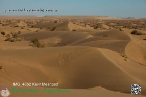
مصر نام روستای کوچکی است که در 55 کیلومتری شهرستان خور از توابع استان اصفهان واقع شده و ۱۸۰ نفر(41 خانوار) جمعیت دارد .مصر در میانه راه دامغان به نائین و اصفهان قرار دارد. این کویر توسط رشته کوههایی از جانب غرب، جنوب غرب و جنوب شرق محاصره میشود که بخشی از سلسله جبال کوههای فلات مرکزی ایران به حساب میآیند. این کویر در گودالهایی طبیعی در کوهپایههای این کوهها، تپههای ماسهای زیبایی را تشکیل داده است.
Messr is the name of a small village in a beautiful desert located 55 kilometers from the city of Khor of Isfahan province and has a population of 180 people (41 households). The desert is surrounded by mountain ranges from the west, southwest and southeast that form part of the mountains of the Central Plateau of Iran. The desert forms beautiful sand dunes in natural pits in the foothills of these mountains.
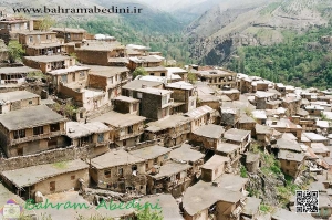
این روستا در دامنه کوه های بینالود و در ۱۹ کیلومتری غرب طرقبه و ۲۹ کیلومتری مشهد واقع شده است. ادارای قدمتی طولانی می باشد و به دلیل استقرار سکونت گاه های آن بر روی کوهپایه شکلی پلکانی پیدا کرده است.همچنین این روستا دارای آب و هوای معتدل و چشم اندازهای زیبای کوهستانی ، رودخانه و چشمه می باشد. ارتفاع آن از سطح دریا 1800 متر می باشد. براساس سرشماری مرکز آمار ایران در سال ۱۳۸۵، جمعیت آن ۱٬۴۷۲ نفر (۳۵۴ خانوار) بودهاست. ولی در سال ۱۳۹۰ جمعیت این روستا به ۷۹۹ نفر (۲۷۱ خانوار) کاهش یافتهاست..
The Kang village is located on the slopes of the Binalood Mountains,. The village has a long history and is a stepped slope due to its settlements.The Kang village is located on the slopes of the Binalood Mountains, 2 km west of Tarkheba and 2 km from Mashhad. The village has a long history and is a stepped slope due to its settlements.The village also has temperate climate and beautiful mountain, river and fountain views. Its altitude is 1800 meters. According to the Census Bureau of Iran in year 2, its population was 2.7 (2 households). But in year 2 the population of this village has been reduced to 4 persons (2 households).
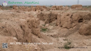
کهن دژ نیشابور واقع در خراسان مرکزی می باشد؛ که در جنوب شهر فعلی نیشابور به صورت تپه های باستانی قرار گرفته است. این سایت دو بار توسط باستان شناسان مورد حفاری وبررسی قرار گرفته است. بار نخست در حد فاصل سالهاي 1935 تا 1948 يك هيأت اعزامي از موزه متروپليتن نيويورك كاوشهايي را در منطقه نيشابور انجام داد كه از جمله مناطق مطالعه شده اين گروه محوطه كهن دژ بود؛ که قدمت آنرا به دوران سامانی وسلجوقی نسبت دادند. اما در فصل دوم بررسی که توسط هیات فرانسوی در سال 1383انجام شد، کارشناسان قدمت آنرا به دوران ساسانیان مربوط دانستند. در این منطقه 24هزار شی تاریخی از جمله سفال های گوناگون و به ویژه یک درفش ساسانی کشف شده است. متاسفانه این سایت همواره با چپاول و غارت همراه بوده است.
The ancient Neyshabur citadel is located in central Khorasan, to the south of the current Neyshabur city as ancient hills. The site has been excavated twice by archaeologists. For the first time between 1935 and 1948, a delegation from the New York Metropolitan Museum carried out excavations in the Neyshabur area, including the study area of this ancient fortified area, dating back to the Sultanate and Seleucid era. But in the second chapter of the study conducted by the French delegation in 2004, experts attributed it to antiquity in the Sassanid era. In the area, 24,000 historical objects have been discovered, including pottery, and in particular a Sassanid drapery. Unfortunately, this site has always been looted and looted.

عیش آباد روستایی در نیشابور و در استان خراسان رضوی می باشد.این روستا دارای مسیری برای صعود به قله بینالود می باشد. عیش آباد روستایی در نیشابور و در استان خراسان رضوی می باشد.این روستا دارای مسیری برای صعود به قله بینالود می باشد. براساس سرشماری مرکز آمار ایران در سال ۱۳۸۵، جمعیت آن ۱۵۸ نفر (۳۷خانوار) بوده است.
Eyshabad is a village in Mazul Rural District, in the Central District of Nishapur County, Razavi Khorasan Province, Iran. At the 2006 census, its population was 158, in 37 families.
این مسجد در خراسان جنوبی، شهر قاین قرار دارد. قدمت این بنا به سده هشتم ه.ق(دوره تیموریان) بر میگردد و به شیوه آذری ساخته شده است. اما گروهی از باستان شناسان مقعتقدند این بنا قبلا آتشکده بوده است.(به دلیل مشاهده آثار تنور در شبستان غربی).این مسجد دارای مساحتی بالغ بر 2470 متر مربع است که 65 متر طول و 38متر عرض دارد.نمای آن آجری و دارای دو در ورودی شرقی و شمالی و 11 پنجره از نمای خارجی می باشد. درب اصلی آن شرقی می باشد که روبروی ایوان اصلی مسجد قرار دارد. همچنین این بنا دارای دو شبستان شرقی و غربی است که 18متر ارتفاع ، 11متر عرض و 22متر طول است.صحن این مسجد دارای 22رواق است. در ایوان مسجد در وسط دیوار جنوب محراب اول قرار دارد که به سمت بیت المقدس است و در جنوب غربی آن محراب دوم قرار دارد که رو به کعبه ساخته شده است
This mosque is located in the south of Khorasan, Qain city. It dates back to the 8th century (Timurid dynasty) and was built in Azeri style. But a group of archaeologists believe that the building was formerly a fireplace (due to the observation of the tenor in the western nave). The entrance is east and north and 11 windows are exterior. Its main door is east facing the main porch of the mosque. It also has two eastern and western niches that are 18 meters high, 11 meters wide and 22 meters long. The mosque has 22 porches. On the porch of the mosque is in the middle of the south wall of the first altar to Jerusalem, and to the southwest of the second altar, which faces the Kaaba.
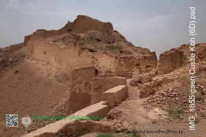
این قلعه در استان خراسان جنوبی در شهر قائن قرار دارد و مربوط به دوره سلجوقی می باشد که توسط فداییان اسماعیلیه مورد استفاده قرار می گرفته است. البته برخی منابع قدمت این بنا را تا دوران هخامنشیان تخمین می زنند.این قلعه در استان خراسان جنوبی در شهر قائن قرار دارد و مربوط به دوره سلجوقی می باشد که توسط فداییان اسماعیلیه مورد استفاده قرار می گرفته است. البته برخی منابع قدمت این بنا را تا دوران هخامنشیان تخمین می زنند.این قعله در محوطه ای وسیع به طول 600متر روی کوه احداث شده معماری قلعه با استفاده از پستی و بلندیهای کوه از دو قسمت متمایز ساخته شده است یکی قسمت سربازان و جنگجویان ودیگر قسمت امیر نشین و فرماندهی این دژ از سمت جنوب و جنوب شرق به کوهستان و از سمت غرب وشمال به دشت قاین محدود شده راه رسیدن به قلعه از دره ای در غرب آن میگذرد.
The castle is located in the south of Khorasan province in the city of Qaen and belongs to the Seljuk period used by the Ismaili Fadayans. Some sources, however, estimate that the building dates back to the Achaemenid period.The castle is located in the south of Khorasan province in the city of Qaen and belongs to the Seljuk period used by the Ismaili Fadayans. Some sources, however, estimate that the building dates back to the Achaemenid period.Built on a 600-meter-wide enclosure on the mountain, the castle's architecture is constructed using two distinct mountain slopes, one of soldiers and warriors and the other of the emirate and command of the fort from the south and southeast of the mountain. From the west and the north to the confined plain of Qain, the road to the castle passes through a valley to the west.

گردنه عسلک مرز بین جاده چالوس و شهرستان طالقان است که اگر از جاده چالوس به طرف طالقان بروید در مسیر غار یخ مراد و بعد از غار به آزاد بر و گردنه میرسید گردنه راه ورود به قلل هفت خوان وکلاش ویا است بعد از گردنه به روستاهای گراپ دراپی و گته ده میرسید.
The Asalak ridge is the border between Chalus Road and Taleghan city. If you go to Taleghan Road from Chalus Road, you will reach Yakh Morad Cave and after the cave you will find the path to Haft Juan clash or Vulya Peak. Drop and Goethe-ten.
قله هفت خوان کرج از ارتفاعات البرز مرکزی در جاده چالوس قرار دارد راه دستیابی به قله از چندین مسیر اتفاق می افتد مسیر روستای اویزر که خیلی طولانی است راه روستای سپهسالار و راه آزاد بر از سمت شرق و راه گردنه عسلک که کوتاه ترین مسیر را دارد ارتفاع قله (سه هزارو نه صدو شصت و چهار ) متر با GPS دوربین عکاسی و قلل مربوط به این قله به ترتیب کرچان _میش چال _ برج میش چال _کلاش ویا _زرد بند _هفت خوان _ونتار در ادامه کهار _ میشینه نو _ وناز که یک خط الرس جذاب را تشکیل می دهد عکس فوق از یال گردنه عسلک که کمی در روی قله فرعی یعنی سبز کوه سنگهای ریزشی دارد و مسیر را دشوار می کند در تاریخ بیست وهشتم تیر ماه نودو هشت برداشته شده است.همراهان آقایان ناصر میزبانی _ قائم کیانیان _ پویا عطاران _ و غفور اندر جانی
Haft-khaan Karaj Peak from Central Alborz Heights Located on Chalus Road The road to reach the summit from several routes Ovezer Village Road which is very long Sepahsalar village road and east road and the shortest honeycomb road. Peak height (three thousand nine hundred and sixty-four) meters with GPS camera and peaks related to this peak in Kerchan - Mishal Chal - Mish Chal - Clash or Zardash - Seven Readers - Seven Readers - Continental Kahar - Mishin Noor - Venaz which is a ridge This is a photo of a honeycomb trailer that has a bit of a pebble on the side of the mountain, making the route difficult. Dated on July 28, the eighth day of July, the eighth day has been removed. The companions of Mr. Nasser Hosting - Ghaem Kianian - Pouya Attaran - and Gafour Andrew Jani
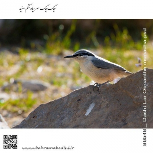
دشت لار علاوه بر اینکه دارای دریاچه رودخانه کوه آبشار چشمه و بسیاری دیگر .... پرندگان بیشماری دارد از جمله چک چک که در تمام منطقه لار دیده می شود و با گنجشگ از نظر غذائی زیاد فرقی ندارد و بیشتر در طبیعت بکر دیده می شود. در مدت نیم ساعتی که یک جا نشتم از پرندگان عکس بگیرم این پرنده در پشت سر من در فاصله دو متری نشت وچند عکسی از ایشون گرفتم