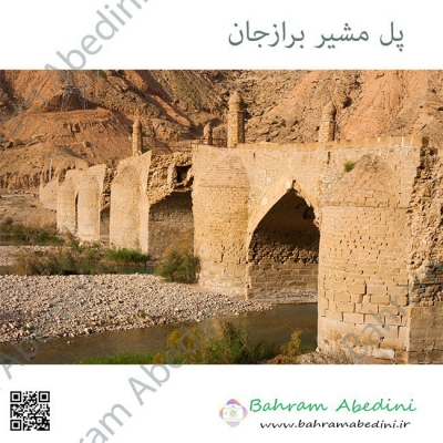
")
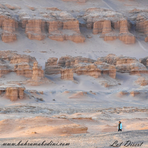
عکسی از کویر لوت
Farsi Description:
کویر لوت، که به عنوان دشت لوت نیز شناخته میشود، یک بیابان نمکی وسیع در جنوب شرقی ایران است. این یکی از گرمترین و خشکترین مکانهای زمین است که دمای سطح آن به شدت بالا میرسد. این بیابان حدود ۵۱٬۸۰۰ کیلومتر مربع را پوشش میدهد و دارای ویژگیهای زمینشناسی منحصر به فردی مانند یاردانگهای عظیم، بیابانهای سنگی گسترده و برخی از بلندترین تپههای شنی جهان است. این منطقه بادهای قوی را تجربه میکند که چشمانداز دراماتیک آن را شکل میدهند. در سال ۲۰۱۶، بیابان لوت به عنوان یک سایت میراث جهانی یونسکو به دلیل زیبایی طبیعی و اهمیت زمینشناسی آن شناخته شد.
به این عکس امتیاز دهید.
این عکس توسط بهرام عابدینی از تپه ها و طبیعت اطراف این منطقه گرفته شده است. برای خرید این عکس یا عکس های دیگر از طریق وبسایت یا تلفن با ما تماس بگیرید.
توضیحات انگلیسی:
The Lut Desert, also known as Dasht-e Lut, or Kavir_e Lut is a vast salt desert in southeastern Iran. It is one of the hottest and driest places on Earth, with surface temperatures reaching extreme highs. Covering about 51,800 square kilometers, it features unique geological formations like massive yardangs, extensive stony deserts, and some of the world's tallest sand dunes. The region experiences strong winds that shape its dramatic landscape. In 2016, the Lut Desert was recognized as a UNESCO World Heritage Site for its natural beauty and geological significance.
Please rate this picture.
This picture is taken by Bahram Abedini. If you want to purchase this picture or any other around this area please contact us through website, email or phone.
We sell pictures digitally in Large format and internationally through secure paypal payment in the US.
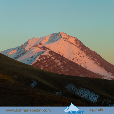
قله لیچه در استان البرز

Farsi Description:
قله لیچه به ارتفاع 2900 در استان البرز در شرق روستای کندور و در غرب روستای واریش تهران قرار دارد مسیرهای صعود روستای کندور و روستای واریش میباشد لیچه همجوار با کوه چشمه شاهی ودر ادامه یال به قله لیز و لیزان متصل می شود ارتفاع قله 2900 متر واین عکس از جاده قدیم کندور زیر قله پورا گرفته شده
به این عکس امتیاز دهید.
این عکس توسط بهرام عابدینی از تپه ها و طبیعت اطراف این منطقه گرفته شده است. برای خرید این عکس یا عکس های دیگر از طریق وبسایت یا تلفن با ما تماس بگیرید.
توضیحات انگلیسی:
"Liche Peak, with an elevation of 2900 meters, is located in Alborz Province, east of Kondor village and west of Varish village in Tehran. The ascent routes are from Kondor village and Varish village. Liche is adjacent to Cheshmeh Shahi mountain and continues along the ridge to connect to Liz and Lizan peaks. The elevation of the peak is 2900 meters, and this photo was taken from the old Kondor road below Pura Peak."
Please rate this picture.
This picture is taken by Bahram Abedini. If you want to purchase this picture or any other around this area please contact us through website, email or phone.
We sell pictures digitally in Large format and internationally through secure paypal payment in the US.
قبرستان قدیمی موجومبار

Farsi Description:
گورستان مجومبار در شبستر، آذربایجان شرقی، ایران، از نظر تاریخی اهمیت زیادی دارد و میراث ارمنی روستا را منعکس میکند. این مکان شامل کلیسای سنت هریپسیمه است که به قرون 9 تا 13 میلادی بازمیگردد و بینشهایی در مورد زندگی و سنتهای جامعه ارمنی که زمانی در این منطقه رونق داشتند، ارائه میدهد. سنگقبرها و کتیبههای گورستان، یاد و خاطره این جامعه را حفظ میکنند.
به این عکس امتیاز دهید.
این عکس توسط بهرام عابدینی از تپه ها و طبیعت اطراف این منطقه گرفته شده است. برای خرید این عکس یا عکس های دیگر از طریق وبسایت یا تلفن با ما تماس بگیرید.
توضیحات انگلیسی:
Mujumbar Cemetery in Shabestar, East Azerbaijan, Iran, is historically significant, reflecting the village’s Armenian heritage. It features the Saint Hripsime Church, dating from the 9th to 13th centuries, and offers insights into the lives and traditions of the Armenian community that once thrived there. The cemetery’s tombstones and inscriptions preserve the memory of this community.
Please rate this picture.
This picture is taken by Bahram Abedini. If you want to purchase this picture or any other around this area please contact us through website, email or phone.
خراسان مرکزی کلات دره قله زو (سنگ اسب)
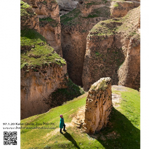
سنگ اسب نام صخره ای است در دره ی قله زو که یکی از شگفتی های طبیعت استان خراسان است. در این عکس با قیاس شخصی که در کنار صخره ایستاده میتوانید به بزرگی این صخره و مجموعه پی برد.
دره شاه دژ و قله پورا
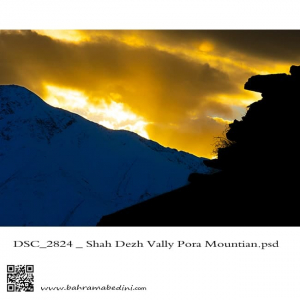
The valley of Shah dej in a sunset
This picture has been taken on my recent hiking in the region , the summit in the picture is the Poora peak
دره شاه دژ و قله پورا در پس زمینه
صخره های البرز
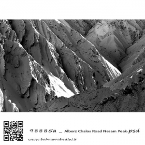
Alborz mountain, The summit of Nesam. A black and white abstract photography
کوه های آزاد کوه ، قله نسام. عکسی سیاه و سفید از طبیعت ایران
در راه عروسی
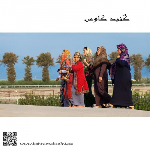
Group of women In local costumes
North Iran , Gonbad Kavoos
گروهی از زنان گنبد کاووس در راه مراسم عروسی
قله تمندر در الیگودرز
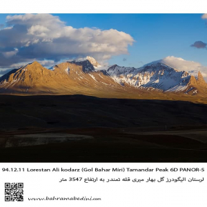
This is western Iran on the mountain range of Alborz. The summit is called Tamandar and is in city of Aligoodarz in province of Lorestan.
قله تمندر در شهر لرستان و منطقه گل بهار میری . در استان لرستان.
دریاچه سوها
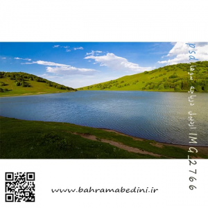
North west Iran
Close to the beautiful city of Ardebil
دریاچه سوها در نزدیکی شهر زیبای اردبیل
قله شاه کرم، کوه های طالقان
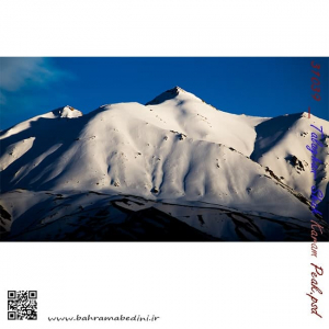
Shah Karam mountain
in the region of Taleghan, north central Iran
طالقان خچیره قله شاه کرم
عظمت و بزرگی کوه های ایران بسیار چشمگیر و زیبا هست و برف این زیبایی را دو چندان میکند. طالقان جزء روستاهایی هست که دور تا دور آن را کوه محاصره کرده و منطقه کوهستانی زیبایی رو به وجود آورده است.
برای خرید این عکس یا دیگر عکس های با ما تماس بگیرید.