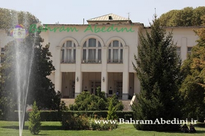
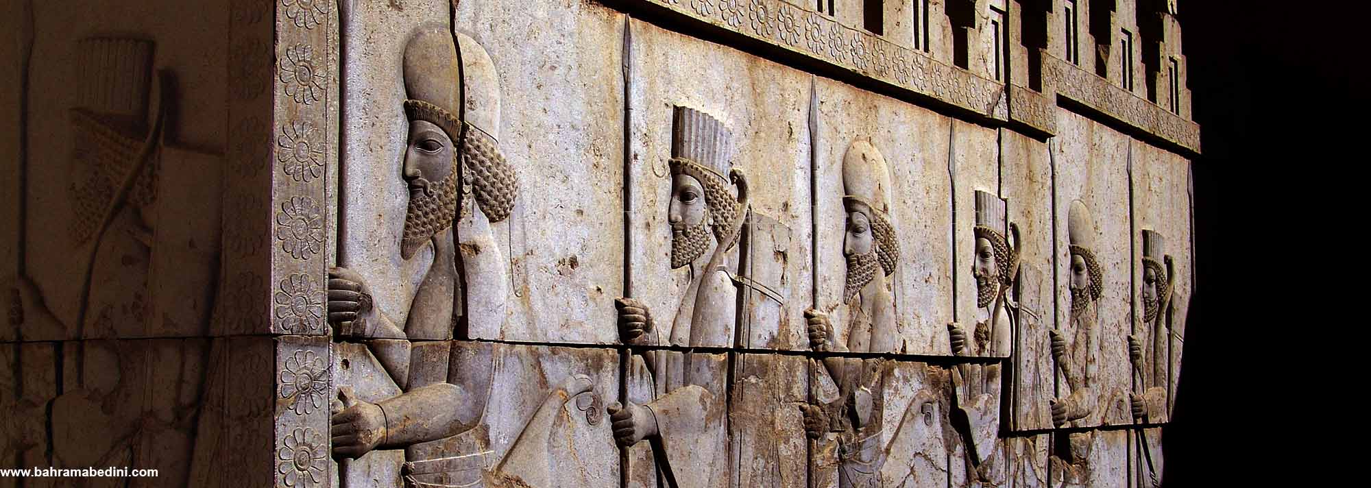
عکس های آثار تاریخی و باستانی ایران
عکس های آثار تاریخی و باستانی ایران
عکس های آثار تاریخی و باستانی ایران
بهرام عابدینی
بهرام عابدینی
بهرام عابدینی
Website Language

")
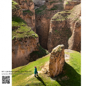
سنگ اسب نام صخره ای است در دره ی قله زو که یکی از شگفتی های طبیعت استان خراسان است. در این عکس با قیاس شخصی که در کنار صخره ایستاده میتوانید به بزرگی این صخره و مجموعه پی برد.
دره گنکرلا در شمال ایران
Gankarla valley,
north of Iran
Chaloos - Tehran
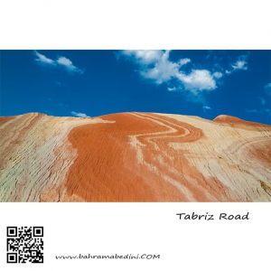
این عکس از یکی از تپه های جاده تبریز گرفته شده است.
this swirl of natural colors from minerals is on a hill on the road from Tehran to Tabriz.
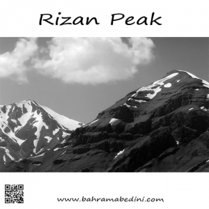
قله ریزان همراه با آتشکوه
The mountain of Rizan on the right and Atashkooh mountain on the left in black and white
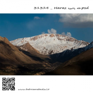
البرز شرقی قله پاشوره 3900 متر در جوار قله عبرت وقله امیری
This is a picture from the eastern Alborz mountain range. The peak in the picture is called Pashooreh, it has a height of 3900 meters from mean sea level which is (12795.28 ft) . the other summit beside it , is called Ebrat summit. and the other one, Amiri summit.
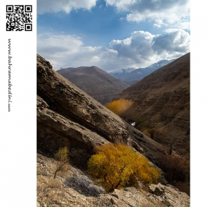
Mountain photography is the art of capturing nature at its core, and having the colors as natural as it can be. The framing is also important in mountain photography. it should be very inclusive of the nature around the mountains. Light in nature photography is important as to help viewers get the feeling of the nature right there. Therefore, it is not advisable to always have a bright and high visibility. Nature as it comes has darkness and brightness. there is sunrise and sunset and all makes different lighting in the atmosphere around it.
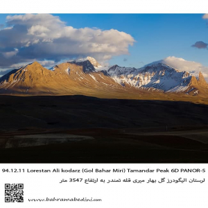
This is western Iran on the mountain range of Alborz. The summit is called Tamandar and is in city of Aligoodarz in province of Lorestan.
قله تمندر در شهر لرستان و منطقه گل بهار میری . در استان لرستان.
North west Iran
Close to the beautiful city of Ardebil
دریاچه سوها در نزدیکی شهر زیبای اردبیل
كوههاى پوشده از برف در شمال ايران
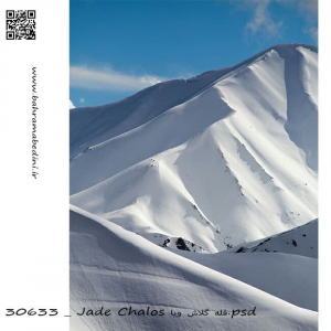
قله كلاش ویا در البرز مرکزی به ارتفاع 3900متر
در زبان مازني كلاش به معني عنكبوت و ويا به معني رشته نخ ميباشد
Kalash Viya summit of Alborz mountain series
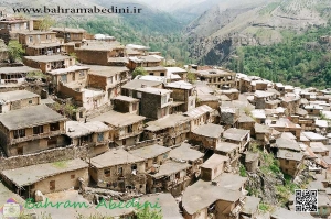
این روستا در دامنه کوه های بینالود و در ۱۹ کیلومتری غرب طرقبه و ۲۹ کیلومتری مشهد واقع شده است. ادارای قدمتی طولانی می باشد و به دلیل استقرار سکونت گاه های آن بر روی کوهپایه شکلی پلکانی پیدا کرده است.همچنین این روستا دارای آب و هوای معتدل و چشم اندازهای زیبای کوهستانی ، رودخانه و چشمه می باشد. ارتفاع آن از سطح دریا 1800 متر می باشد. براساس سرشماری مرکز آمار ایران در سال ۱۳۸۵، جمعیت آن ۱٬۴۷۲ نفر (۳۵۴ خانوار) بودهاست. ولی در سال ۱۳۹۰ جمعیت این روستا به ۷۹۹ نفر (۲۷۱ خانوار) کاهش یافتهاست..
The Kang village is located on the slopes of the Binalood Mountains,. The village has a long history and is a stepped slope due to its settlements.The Kang village is located on the slopes of the Binalood Mountains, 2 km west of Tarkheba and 2 km from Mashhad. The village has a long history and is a stepped slope due to its settlements.The village also has temperate climate and beautiful mountain, river and fountain views. Its altitude is 1800 meters. According to the Census Bureau of Iran in year 2, its population was 2.7 (2 households). But in year 2 the population of this village has been reduced to 4 persons (2 households).
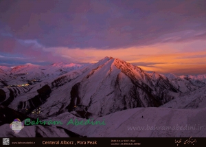
.قله پورا در البرز مرکزی در استان کرج واقع است ومابین کوهای پهنه حصار، چشمه شاهی، چال، شاهدژ ، پیله ، خونکهار قرار دارد وتنها آبشار و آبریز آن آبشار نمرک است.که از سمت جنوب قله جریان دارد ارتفاع قله حدود دو هزارو نصد متر است که در قسمت جنوبی کمی صخره ای است
قله پورا از جنوب به روستای کندر ، از شمال به روستای ابهرک و ارنگه ، از غرب به روستای آدران و از شرق بر روی خط الراس با گذر از قلل چال ، سیوچال ، درزو و پشته بند به قله پهنه سار منتهی می شود.
اگر به عکس های کوه های ایران علاقه دارید میتوانید برای سفارش با ما تماس بگیرید. عکس حاضر به خانم مولاپنا به صورت چاپی فروخته شده است .