آخرین عکس های طبیعت و مناظر ایران
بهرام عابدینی
آخرین عکس های طبیعت و مناظر ایران
آخرین عکس های طبیعت و مناظر ایران
بهرام عابدینی
بهرام عابدینی
Website Language

")


Farsi Description:
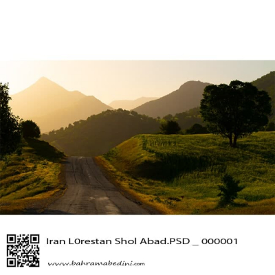
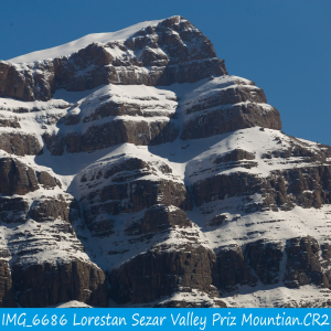
در استان لرستان، دره سزار یکی از زیباترین درههای کوهستانی است که در نزدیکی شهرستان دورود قرار دارد و رودخانه سزار با آب خروشان و طبیعت سرسبز از میان آن عبور میکند. در امتداد این منطقه، قله پریز با ارتفاعی حدود ۳۱۰۰ متر از جاذبههای مهم کوهنوردی به شمار میآید. این قله چشماندازهای گسترده، چشمههای زلال و غارهای طبیعی دارد و مسیر صعود آن از دورود آغاز میشود. ترکیب رودخانه سزار، صخرههای آهکی، پوشش گیاهی متنوع و هوای پاک، این منطقه را به مقصدی محبوب برای طبیعتگردان و کوهنوردان تبدیل کرده است.
به این عکس امتیاز دهید.
این عکس توسط بهرام عابدینی از تپه ها و طبیعت اطراف این منطقه گرفته شده است. برای خرید این عکس یا عکس های دیگر از طریق وبسایت یا تلفن با ما تماس بگیرید.
توضیحات انگلیسی:
In Lorestan Province, Sezar Valley is one of the most beautiful mountain gorges, located near Dorud, where the Sezar River flows through with rushing waters and lush scenery. Along this area, Pariz Peak, standing at about 3,100 meters, is a major attraction for mountaineers. The peak offers wide panoramic views, clear springs, and natural caves, with the main climbing route starting from Dorud. The combination of the Sezar River, limestone cliffs, diverse vegetation, and fresh mountain air makes this region a popular destination for nature lovers and hikers.
Please rate this picture.
This picture is taken by Bahram Abedini. If you want to purchase this picture or any other around this area please contact us through website, email or phone.
We sell pictures digitally in Large format and internationally through secure paypal payment in the US. Just let us know which picture you like through here: Contact-us
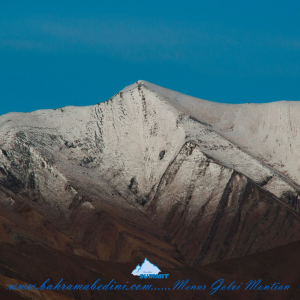
Farsi Description:
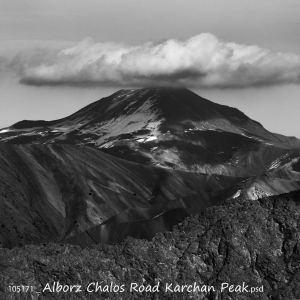
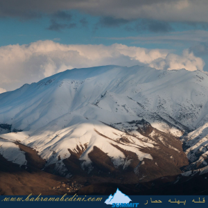
قلهٔ کرچان در رشتهکوه البرز مرکزی واقع شده و یکی از قلههای محبوب کوهنوردان است. این قله با ارتفاعی حدود ۳۹۰۰ متر (بسته به مسیر اندازهگیری) چشماندازی وسیع به دشت هراز، قلههای دماوند و منطقهٔ پلور دارد. مسیرهای صعود معمولاً از روستاهای نوا یا پلور آغاز میشود و به دلیل مناظر بکر، سکوت کوهستان و نزدیکی به تهران مقصدی جذاب برای صعود یکروزه یا دوروزه است.
به این عکس امتیاز دهید.
این عکس توسط بهرام عابدینی از تپه ها و طبیعت اطراف این منطقه گرفته شده است. برای خرید این عکس یا عکس های دیگر از طریق وبسایت یا تلفن با ما تماس بگیرید.
توضیحات انگلیسی:
Karchan Peak is located in the Central Alborz mountain range and is a popular destination for climbers. Standing at an elevation of about 3,900 m, it offers wide, breathtaking views of the Haraz plain, Mount Damavand, and the surrounding Plour region. The usual ascent routes start from the villages of Nava or Plour, making it an attractive choice for a one-day or two-day climb thanks to its pristine landscapes, peaceful mountain atmosphere, and convenient access from Tehran.
Please rate this picture.
This picture is taken by Bahram Abedini. If you want to purchase this picture or any other around this area please contact us through website, email or phone.
We sell pictures digitally in Large format and internationally through secure paypal payment in the US.
Farsi Description:
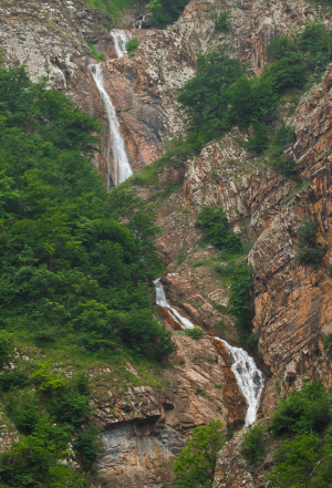
آبشار آندرس مجموعه ای در حدود 50 آبشار پشت سر هم است که در طبقه بندی آبشارها آبشار پله ای طبقه بندی میشود که در این رابطه میتوانید کتاب بنده "آبشارهای استان البرز" بیشتر مطالعه کنید. این آبشار از سیاه بیشه قابل روئت است. این آبشار بر روی کوه آرنگ چال قرار دارد.
به این عکس امتیاز دهید.
این عکس توسط بهرام عابدینی از تپه ها و طبیعت اطراف این منطقه گرفته شده است. برای خرید این عکس یا عکس های دیگر از طریق وبسایت یا تلفن با ما تماس بگیرید.
توضیحات انگلیسی:
Anders Waterfall is a series of approximately 50 consecutive waterfalls, which classifies it as a stepped or tiered waterfall. For more information on this type of waterfall, you can refer to my book "The Waterfalls of Alborz Province." This waterfall is visible from Siah Bisheh and is located on Mount Arang Chal.
Waterfalls cascading down from mountains are among the most breathtaking natural phenomena on Earth. They form when rivers or streams, fed by melting snow or rain from high elevations, plunge dramatically over rocky cliffs and steep terrain. As the water descends, it carves through stone, creating misty veils, thunderous sounds, and glistening pools below.
These mountain waterfalls are often tucked within lush forests or rugged alpine landscapes, offering moments of serene beauty and raw power. Their presence not only enhances the visual splendor of mountainous regions but also supports diverse ecosystems, providing moisture and habitat for plants and animals.
Symbolically, mountain waterfalls often represent purity, renewal, and the relentless energy of nature—always flowing, shaping, and giving life. Whether a gentle trickle or a roaring cascade, they remind us of the majesty and movement of the natural world.
Please rate this picture.
This picture is taken by Bahram Abedini. If you want to purchase this picture or any other around this area please contact us through website, email or phone.
We sell pictures digitally in Large format and internationally through secure paypal payment in the US.
Farsi Description:
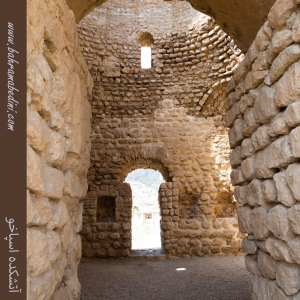
آتشکده اسپاخو بنایی تاریخی از دوره ساسانی است که در روستای اسپاخو در استان خراسان شمالی قرار دارد. این آتشکده با معماری سنگی و گنبدی شکل، دارای سه ورودی و ایوانی بلند در ضلع شرقی است. در گذشته برای نیایش زرتشتیان و نگهداری آتش مقدس استفاده میشد. این بنا یکی از قدیمیترین آثار تاریخی منطقه است و در فهرست آثار ملی ایران ثبت شده است.
به این عکس امتیاز دهید.
این عکس توسط بهرام عابدینی از تپه ها و طبیعت اطراف این منطقه گرفته شده است. برای خرید این عکس یا عکس های دیگر از طریق وبسایت یا تلفن با ما تماس بگیرید.
توضیحات انگلیسی:
The Espakho Fire Temple is a historical structure from the Sassanid era, located in the village of Espakho in North Khorasan Province, Iran. Built with stone and featuring a domed roof, the temple has three entrances and a tall eastern portico. It was used by Zoroastrians for worship and to preserve sacred fire. This temple is one of the oldest surviving monuments in the region and is listed as a national heritage site of Iran.
Please rate this picture.
This picture is taken by Bahram Abedini. If you want to purchase this picture or any other around this area please contact us through website, email or phone.
We sell pictures digitally in Large format and internationally through secure paypal payment in the US.
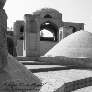
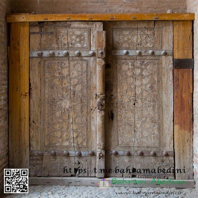
Farsi Description:
مسجد خسرو یکی از بناهای تاریخی شهر اردستان در استان اصفهان است که در دوره صفوی ساخته شده. این مسجد که به «مسجد آخوند» نیز معروف است، در محله راهمیان و خیابان دوازدهم بهمن قرار دارد و بهعنوان یکی از آثار ملی ایران به ثبت رسیده است.
به این عکس امتیاز دهید.
این عکس توسط بهرام عابدینی از تپه ها و طبیعت اطراف این منطقه گرفته شده است. برای خرید این عکس یا عکس های دیگر از طریق وبسایت یا تلفن با ما تماس بگیرید.
توضیحات انگلیسی:
Khosrow Mosque is a historical building located in the city of Ardestan, in Isfahan Province, Iran. It was built during the Safavid era and is also known as “Akhund Mosque.” Situated in the Rahmiyan neighborhood on 12th Bahman Street, it has been registered as a national heritage site of Iran.
Please rate this picture.
This picture is taken by Bahram Abedini. If you want to purchase this picture or any other around this area please contact us through website, email or phone.
We sell pictures digitally in Large format and internationally through secure paypal payment in the US.
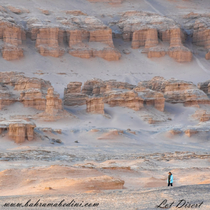
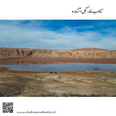
Farsi Description:
کویر لوت، که به عنوان دشت لوت نیز شناخته میشود، یک بیابان نمکی وسیع در جنوب شرقی ایران است. این یکی از گرمترین و خشکترین مکانهای زمین است که دمای سطح آن به شدت بالا میرسد. این بیابان حدود ۵۱٬۸۰۰ کیلومتر مربع را پوشش میدهد و دارای ویژگیهای زمینشناسی منحصر به فردی مانند یاردانگهای عظیم، بیابانهای سنگی گسترده و برخی از بلندترین تپههای شنی جهان است. این منطقه بادهای قوی را تجربه میکند که چشمانداز دراماتیک آن را شکل میدهند. در سال ۲۰۱۶، بیابان لوت به عنوان یک سایت میراث جهانی یونسکو به دلیل زیبایی طبیعی و اهمیت زمینشناسی آن شناخته شد.
به این عکس امتیاز دهید.
این عکس توسط بهرام عابدینی از تپه ها و طبیعت اطراف این منطقه گرفته شده است. برای خرید این عکس یا عکس های دیگر از طریق وبسایت یا تلفن با ما تماس بگیرید.
توضیحات انگلیسی:
The Lut Desert, also known as Dasht-e Lut, or Kavir_e Lut is a vast salt desert in southeastern Iran. It is one of the hottest and driest places on Earth, with surface temperatures reaching extreme highs. Covering about 51,800 square kilometers, it features unique geological formations like massive yardangs, extensive stony deserts, and some of the world's tallest sand dunes. The region experiences strong winds that shape its dramatic landscape. In 2016, the Lut Desert was recognized as a UNESCO World Heritage Site for its natural beauty and geological significance.
Please rate this picture.
This picture is taken by Bahram Abedini. If you want to purchase this picture or any other around this area please contact us through website, email or phone.
We sell pictures digitally in Large format and internationally through secure paypal payment in the US.
Farsi Description:
قله منا ر و گلوی به ارتفاع تقریبی سه وهزارو پانصد متر در شمال روستای واریان وجنوب شرقی روستای مورودقرار دارد این دوقله در خطالراس سیاه سنگ منار و گلوی و گلو سربند واقع است راه صعود به قله بیشتر از روستای مورود است آبشار های که از قله ها سرازیر می شود یکی آبشا ر چهار صد تنور در جنوب و آبشار رفک در شمال این کوه قرار دارد.
به این عکس امتیاز دهید.
این عکس توسط بهرام عابدینی از تپه ها و طبیعت اطراف این منطقه گرفته شده است. برای خرید این عکس یا عکس های دیگر از طریق وبسایت یا تلفن با ما تماس بگیرید.
توضیحات انگلیسی:
Please rate this picture.
The peaks of Manar and Golou, with an approximate height of 3,500 meters, are located north of the village of Varyan and southeast of the village of Moroud. These two peaks are situated on the ridge of Siah Sang Manar and Golou and Golou Sarband. The main route to ascend the peaks is from the village of Moroud. The waterfalls that flow from the peaks include the Four Hundred Tanur waterfall in the south and the Rafak waterfall in the north of this mountain."
This picture is taken by Bahram Abedini. If you want to purchase this picture or any other around this area please contact us through website, email or phone.
We sell pictures digitally in Large format and internationally through secure paypal payment in the US.
Farsi Description:
قلهٔ کرکوه با ارتفاع ۳۱۰۰ متر در درهٔ خور و سیجان واقع شده است. این قله با قلههای پهنهحصار و چال ناجی یال مشترک دارد و آبشارهای زیبای پنجهپلنگ و رفک در دامنههای آن قرار گرفتهاند. منطقهٔ کرکوه با طبیعت بکر، پوشش گیاهی متنوع و چشماندازهای کوهستانی، یکی از مقاصد محبوب کوهنوردان و طبیعتگردان در نزدیکی تهران به شمار میرود.
به این عکس امتیاز دهید.
این عکس توسط بهرام عابدینی از تپه ها و طبیعت اطراف این منطقه گرفته شده است. برای خرید این عکس یا عکس های دیگر از طریق وبسایت یا تلفن با ما تماس بگیرید.
توضیحات انگلیسی:
Mount Karkouh, standing at an elevation of 3,100 meters, is located in the Khur and Sijan valley. It shares a ridge with the peaks of Pahneh Hisar and Chal Naji, and the beautiful waterfalls of Panjeh Palang and Rafak lie at its base. The Karkouh region, with its pristine nature, diverse vegetation, and stunning mountain landscapes, is a popular destination for hikers and nature enthusiasts near Tehran.
Please rate this picture.
This picture is taken by Bahram Abedini. If you want to purchase this picture or any other around this area please contact us through website, email or phone.
We sell pictures digitally in Large format and internationally through secure paypal payment in the US.
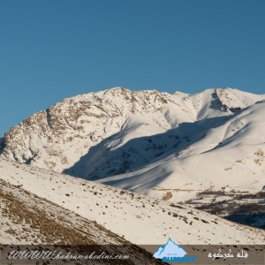
Farsi Description:
کوه پهنه حصار یک قله برجسته در کوههای البرز مرکزی در شمال ایران، نزدیک روستای سنگان بالا است. این کوه به خاطر مسیرهای دیدنی، مناظر متنوع و تنوع زیستی غنی خود شناخته شده است. این منطقه شامل آبشار چشمگیر سنگان نیز میشود که آن را به مقصدی محبوب برای کوهنوردان و علاقهمندان به طبیعت تبدیل کرده است.
به این عکس امتیاز دهید.
این عکس توسط بهرام عابدینی از تپه ها و طبیعت اطراف این منطقه گرفته شده است. برای خرید این عکس یا عکس های دیگر از طریق وبسایت یا تلفن با ما تماس بگیرید.
توضیحات انگلیسی:
The Mountain of Pahne Hesar is a prominent peak in the Central Alborz Mountains of northern Iran, near the village of Sangan Bala. It's known for its scenic trails, diverse landscapes, and rich biodiversity. The area includes the impressive Sangan Waterfall, making it a popular destination for hikers and nature enthusiasts.
Please rate this picture.
This picture is taken by Bahram Abedini. If you want to purchase this picture or any other around this area please contact us through website, email or phone.
We sell pictures digitally in Large format and internationally through secure paypal payment in the US.
Farsi Description:
قله پورا از جنوب به روستای کندر ، از شمال به روستای ابهرک و ارنگه ، از غرب به روستای آدران و از شرق بر روی خط الراس قلل چال ، سیوچال ، درزو و پشته بند محراب چشمه شاهی قله پهنه سار امتداد دارد مسیرهای صعود جاده قدیم کندور دره گلنا و آبشار نمرک و روستای ابهرک ارتغاع قله دوهزارو نصد متر است
به این عکس امتیاز دهید.
این عکس توسط بهرام عابدینی از تپه ها و طبیعت اطراف این منطقه گرفته شده است. برای خرید این عکس یا عکس های دیگر از طریق وبسایت یا تلفن با ما تماس بگیرید.
توضیحات انگلیسی:
Pura Peak is bordered to the south by the village of Kondor, to the north by the villages of Abharak and Arangeh, to the west by the village of Adran, and to the east along the ridge line of Chal, Sivchal, Darzu, and Pusht-e Band Mehrab Cheshmeh Shahi peaks, extending to Pahne Sar Peak. The ascent routes include the old Kondor Road, Golna Valley, Namrak Waterfall, and the village of Abharak. The peak's elevation is 2,900 meters.
Please rate this picture.
This picture is taken by Bahram Abedini. If you want to purchase this picture or any other around this area please contact us through website, email or phone.
We sell pictures digitally in Large format and internationally through secure paypal payment in the US.