آخرین عکس های طبیعت و مناظر ایران
بهرام عابدینی
آخرین عکس های طبیعت و مناظر ایران
آخرین عکس های طبیعت و مناظر ایران
بهرام عابدینی
بهرام عابدینی
Website Language

")

Farsi Description:
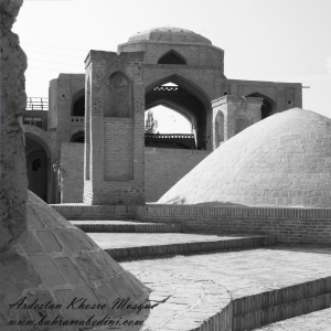
مسجد خسرو یکی از بناهای تاریخی شهر اردستان در استان اصفهان است که در دوره صفوی ساخته شده. این مسجد که به «مسجد آخوند» نیز معروف است، در محله راهمیان و خیابان دوازدهم بهمن قرار دارد و بهعنوان یکی از آثار ملی ایران به ثبت رسیده است.
به این عکس امتیاز دهید.
این عکس توسط بهرام عابدینی از تپه ها و طبیعت اطراف این منطقه گرفته شده است. برای خرید این عکس یا عکس های دیگر از طریق وبسایت یا تلفن با ما تماس بگیرید.
توضیحات انگلیسی:
Khosrow Mosque is a historical building located in the city of Ardestan, in Isfahan Province, Iran. It was built during the Safavid era and is also known as “Akhund Mosque.” Situated in the Rahmiyan neighborhood on 12th Bahman Street, it has been registered as a national heritage site of Iran.
Please rate this picture.
This picture is taken by Bahram Abedini. If you want to purchase this picture or any other around this area please contact us through website, email or phone.
We sell pictures digitally in Large format and internationally through secure paypal payment in the US.
Farsi Description:
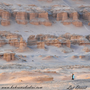
کویر لوت، که به عنوان دشت لوت نیز شناخته میشود، یک بیابان نمکی وسیع در جنوب شرقی ایران است. این یکی از گرمترین و خشکترین مکانهای زمین است که دمای سطح آن به شدت بالا میرسد. این بیابان حدود ۵۱٬۸۰۰ کیلومتر مربع را پوشش میدهد و دارای ویژگیهای زمینشناسی منحصر به فردی مانند یاردانگهای عظیم، بیابانهای سنگی گسترده و برخی از بلندترین تپههای شنی جهان است. این منطقه بادهای قوی را تجربه میکند که چشمانداز دراماتیک آن را شکل میدهند. در سال ۲۰۱۶، بیابان لوت به عنوان یک سایت میراث جهانی یونسکو به دلیل زیبایی طبیعی و اهمیت زمینشناسی آن شناخته شد.
به این عکس امتیاز دهید.
این عکس توسط بهرام عابدینی از تپه ها و طبیعت اطراف این منطقه گرفته شده است. برای خرید این عکس یا عکس های دیگر از طریق وبسایت یا تلفن با ما تماس بگیرید.
توضیحات انگلیسی:
The Lut Desert, also known as Dasht-e Lut, or Kavir_e Lut is a vast salt desert in southeastern Iran. It is one of the hottest and driest places on Earth, with surface temperatures reaching extreme highs. Covering about 51,800 square kilometers, it features unique geological formations like massive yardangs, extensive stony deserts, and some of the world's tallest sand dunes. The region experiences strong winds that shape its dramatic landscape. In 2016, the Lut Desert was recognized as a UNESCO World Heritage Site for its natural beauty and geological significance.
Please rate this picture.
This picture is taken by Bahram Abedini. If you want to purchase this picture or any other around this area please contact us through website, email or phone.
We sell pictures digitally in Large format and internationally through secure paypal payment in the US.
Farsi Description:
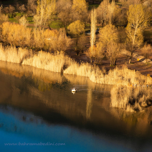
دریاچه اوان در استان قزوین و منطقه الموت قرار دارد. این دریاچه با مساحت ۷۰,۰۰۰ متر مربع و عمق حداکثر ۶.۸ متر، از آب چشمههای زیرزمینی تغذیه میشود. در تابستان برای ماهیگیری و قایقرانی مناسب است و در پاییز محل پرندگان مهاجر میباشد. در زمستان نیز سطح دریاچه یخ میزند و امکان اسکی روی یخ فراهم میشود.
به این عکس امتیاز دهید.
این عکس توسط بهرام عابدینی از تپه ها و طبیعت اطراف این منطقه گرفته شده است. برای خرید این عکس یا عکس های دیگر از طریق وبسایت یا تلفن با ما تماس بگیرید.
توضیحات انگلیسی:
Evan Lake is located in the Alamut region of Qazvin Province. Covering an area of 70,000 square meters with a maximum depth of 6.8 meters, it is fed by underground springs. In summer, it is ideal for fishing and boating, while in autumn, it becomes a haven for migratory birds. In winter, the lake's surface freezes, allowing for ice skating.
Please rate this picture.
This picture is taken by Bahram Abedini. If you want to purchase this picture or any other around this area please contact us through website, email or phone.

Farsi Description:
جادههای پاییزی در میان کوهها با برگهای رنگارنگ و مناظر کوهستانی، یکی از زیباترین مناظر طبیعی را به نمایش میگذارند. جادههایی مانند چالوس، هراز، و سنندج-مریوان با مناظر جنگلی و هوای خنک پاییزی، تجربهای فراموشنشدنی برای مسافران فراهم میکنند.
به این عکس امتیاز دهید.
این عکس توسط بهرام عابدینی از تپه ها و طبیعت اطراف این منطقه گرفته شده است. برای خرید این عکس یا عکس های دیگر از طریق وبسایت یا تلفن با ما تماس بگیرید.
توضیحات انگلیسی:
Autumn roads through the mountains showcase some of the most beautiful natural scenery. With colorful leaves and mountainous landscapes, roads like Chalous, Haraz, and Sanandaj-Marivan offer unforgettable experiences for travelers. The vibrant foliage and cool autumn air make these journeys even more enjoyable.
Please rate this picture.
This picture is taken by Bahram Abedini. If you want to purchase this picture or any other around this area please contact us through website, email or phone.

Farsi description:
قله کلونچی با ارتفاع ۴۲۲۱ متر بلندترین قله رشتهکوه زردکوه بختیاری در استان چهارمحال و بختیاری است. این قله دومین کوه مرتفع در رشتهکوههای زاگرس است و صعود به آن از مسیر تنگه کول خدنگ انجام میشود.
به این عکس امتیاز دهید.
این عکس توسط بهرام عابدینی از تپه ها و طبیعت اطراف این منطقه گرفته شده است. برای خرید این عکس یا عکس های دیگر از طریق وبسایت یا تلفن با ما تماس بگیرید.
توضیحات انگلیسی:
Kolonchi Peak (or Kolonchi) stands at an elevation of 4,221 meters, making it the highest peak in the Zardkuh Bakhtiari mountain range in Chaharmahal and Bakhtiari Province. It is the second highest mountain in the Zagros range and a favorite among professional climbers. The ascent typically starts from the Kol Khodang Gorge.
Please rate this picture.
This picture is taken by Bahram Abedini. If you want to purchase this picture or any other around this area please contact us through website, email or phone.

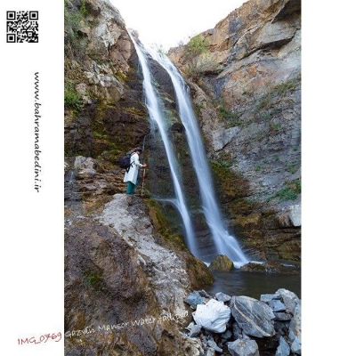
آبشار کلشتر در جنوب غربی شهرستان رودبار و در روستای کلشتر واقع شده است. این آبشار با ارتفاع بیش از ۲۰ متر در میان جنگلهای انبوه قرار دارد و یکی از دیدنیترین آبشارهای گیلان است. برای رسیدن به آبشار، باید از جادههای محلی و جنگلی عبور کرده و حدود ۲۰ تا ۳۰ دقیقه پیادهروی کنید. بهترین زمان برای بازدید فصل بهار و تابستان است که هوا معتدل و طبیعت سرسبز است.
به این عکس امتیاز دهید.
این عکس توسط بهرام عابدینی از تپه ها و طبیعت اطراف این منطقه گرفته شده است. برای خرید این عکس یا عکس های دیگر از طریق وبسایت یا تلفن با ما تماس بگیرید.
English description:
Kalashter Waterfall is located in the southwest of Rudbar County, in the village of Kalashter. This waterfall, with a height of over 20 meters, is nestled among dense forests and is one of the most scenic waterfalls in Gilan Province. To reach the waterfall, you need to travel through local and forest roads and then walk for about 20 to 30 minutes. The best time to visit is during spring and summer when the weather is mild and the nature is lush and green.
Please rate this picture.
This picture is taken by Bahram Abedini. If you want to purchase this picture or any other around this area please contact us through website, email or phone.
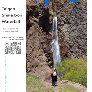
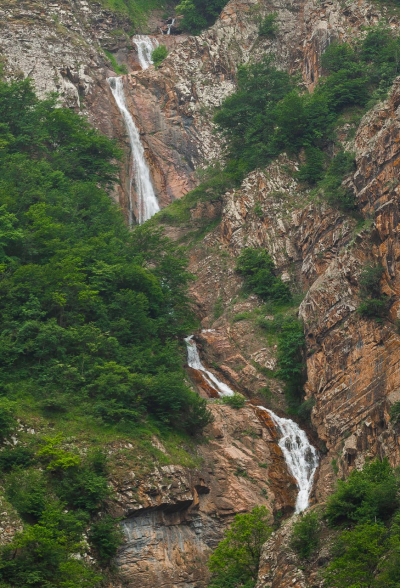
آبشار شاله بن یکی از زیباترین و بکرترین آبشارهای منطقه طالقان در استان البرز ایران است. این آبشار از قلل خسبان سرچشمه میگیرد و سپس به رودخانه خسبان رود میریزد. آبشار شاله بن در غرب روستای بزج و در حدود ۱۰ کیلومتری شمال شهرک طالقان واقع شده است.
مناظر طبیعی اطراف این آبشار بسیار چشمنواز و دلانگیز است و به عنوان یکی از جاذبههای گردشگری محبوب در طالقان شناخته میشود. طبیعت بکر و ناب این منطقه، آن را به مکانی ایدهآل برای علاقهمندان به طبیعتگردی و عکاسی تبدیل کرده است.
به این عکس امتیاز دهید.
این عکس توسط بهرام عابدینی از تپه ها و طبیعت اطراف این منطقه گرفته شده است. برای خرید این عکس یا عکس های دیگر از طریق وبسایت یا تلفن با ما تماس بگیرید.
English description:
Shaleh Bon Waterfall is one of the most beautiful and pristine waterfalls in the Taleghan region of Alborz Province, Iran. This waterfall originates from the Khesban peaks and flows into the Khesban River. It is located to the west of the village of Bozaj and about 10 kilometers north of Taleghan town.
The waterfall is composed of three tiers and has a height of approximately 25 meters. The access route to the waterfall passes through the villages of Khesban and Bozaj, both of which feature stunning natural landscapes and lush gardens. Along the way, you can also visit the Bozaj Cave, which has a depth of about 25 meters.
The best time to visit Shaleh Bon Waterfall is during the spring and summer seasons when the waterfall is more voluminous and the weather is milder. In winter, due to snow and ice, visiting this area can be challenging.
Please rate this picture.
This picture is taken by Bahram Abedini. If you want to purchase this picture or any other around this area please contact us through website, email or phone.
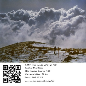
عکسی از قله توچال در سال 1364 در ماه بهمن
مشخصات دوربین و لنز در زیر عکس ذکر شده است.
به این عکس امتیاز دهید.
این عکس توسط بهرام عابدینی از تپه ها و طبیعت اطراف این منطقه گرفته شده است. برای خرید این عکس یا عکس های دیگر از طریق وبسایت یا تلفن با ما تماس بگیرید.
English description:
In 1985, Tochal Mountain in Iran, part of the Alborz range, was a popular destination for its stunning views and rugged terrain. Standing at 3,963 meters, it featured various peaks and trails for hikers and climbers. The Tochal Telecabin, a gondola lift, provided easy access to higher altitudes and the ski resort. The mountain’s proximity to Tehran made it a quick escape for outdoor enthusiasts, with shelters like Shirpala and Siahsang offering rest stops. Overall, Tochal was a cherished natural landmark blending adventure and tranquility.
Please rate this picture.
This picture is taken by Bahram Abedini. If you want to purchase this picture or any other around this area please contact us through website, email or phone.
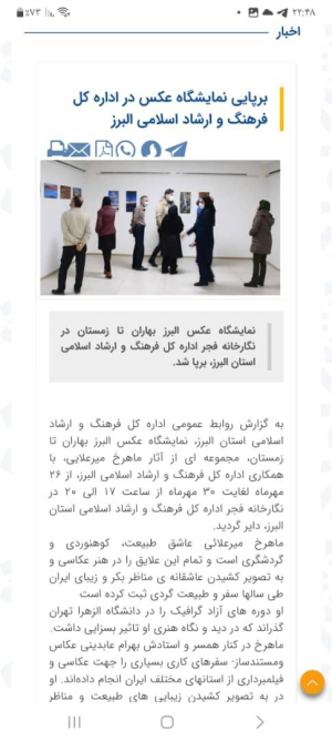
نمایشگاه عکس البرز بهاران تا زمستان در نگارخانه فجر اداره کل فرهنگ و ارشاد اسلامی استان البرز، برپا شد
در این نمایشگاه آثاری منتخب از عکاسی های طبیعت ماهرخ میرعلائی به معرض دید عموم قرار گرفت.
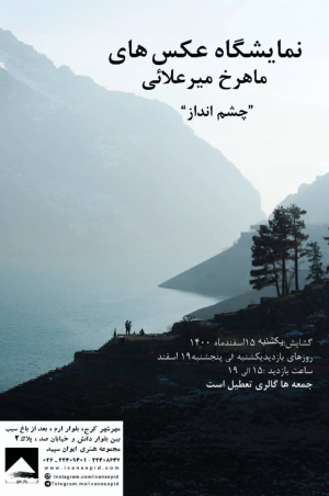
نمایشگاه عکس با عنوان چشم انداز در مجموعه هنری ایوان سپید برگزار میشود.