آخرین عکس های طبیعت و مناظر ایران
بهرام عابدینی
آخرین عکس های طبیعت و مناظر ایران
آخرین عکس های طبیعت و مناظر ایران
بهرام عابدینی
بهرام عابدینی
Website Language

")


Farsi Description:
کوه شاه شهیدان در رشتهکوه زاگرس بختیاری و استان چهارمحال و بختیاری با ارتفاع ۴۲۲۱ متر قرار دارد. این کوه یکی از بلندترین قلل منطقه است و به دلیل مناظر طبیعی زیبا و مسیرهای چالشبرانگیز، مقصدی محبوب برای کوهنوردان حرفهای است.
نام این کوه نباید با کوه دیگری دقیقا با همین نام در استان گیلان اشتباه شود.
به این عکس امتیاز دهید.
این عکس توسط بهرام عابدینی از تپه ها و طبیعت اطراف این منطقه گرفته شده است. برای خرید این عکس یا عکس های دیگر از طریق وبسایت یا تلفن با ما تماس بگیرید.
توضیحات انگلیسی:
Shah Shahidan Mountain in the Zagros Bakhtiari range, located in Chaharmahal and Bakhtiari Province, stands at 4,221 meters. It’s one of the highest peaks in the region and a popular destination for professional climbers due to its beautiful natural scenery and challenging routes.
This mountain should not be confused with the other mountain with the same name in the province of Gilan.
Please rate this picture.
This picture is taken by Bahram Abedini. If you want to purchase this picture or any other around this area please contact us through website, email or phone.

Farsi description:
قله کلونچی با ارتفاع ۴۲۲۱ متر بلندترین قله رشتهکوه زردکوه بختیاری در استان چهارمحال و بختیاری است. این قله دومین کوه مرتفع در رشتهکوههای زاگرس است و صعود به آن از مسیر تنگه کول خدنگ انجام میشود.
به این عکس امتیاز دهید.
این عکس توسط بهرام عابدینی از تپه ها و طبیعت اطراف این منطقه گرفته شده است. برای خرید این عکس یا عکس های دیگر از طریق وبسایت یا تلفن با ما تماس بگیرید.
توضیحات انگلیسی:
Kolonchi Peak (or Kolonchi) stands at an elevation of 4,221 meters, making it the highest peak in the Zardkuh Bakhtiari mountain range in Chaharmahal and Bakhtiari Province. It is the second highest mountain in the Zagros range and a favorite among professional climbers. The ascent typically starts from the Kol Khodang Gorge.
Please rate this picture.
This picture is taken by Bahram Abedini. If you want to purchase this picture or any other around this area please contact us through website, email or phone.
Farsi description:
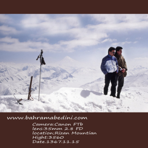
قله ریزان در منطقه لواسانات و نزدیکی روستای افجه قرار دارد و با ارتفاع ۳۵۷۰ متر یکی از مقاصد محبوب کوهنوردان است. مسیر اصلی صعود از دشت هویج آغاز میشود و حدود ۵ ساعت طول میکشد. بهترین زمان برای صعود به این قله، فصل بهار و تابستان است
به این عکس امتیاز دهید.
این عکس توسط بهرام عابدینی از تپه ها و طبیعت اطراف این منطقه گرفته شده است. برای خرید این عکس یا عکس های دیگر از طریق وبسایت یا تلفن با ما تماس بگیرید.
توضیحات انگلیسی:
Mount Rizan is located in the Lavasanat region near the village of Afjeh, with an elevation of 3,570 meters. It's a popular destination for hikers. The main route to the peak starts from the Carrot Plain (Dasht-e Havij) and takes about 5 hours to complete. The best time to hike this peak is during spring and summer.
Please rate this picture.
This picture is taken by Bahram Abedini. If you want to purchase this picture or any other around this area please contact us through website, email or phone.
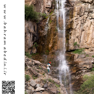
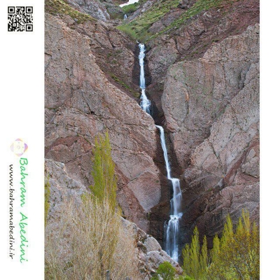
آبشار ورچور در استان قزوین به ارتفاع 30 متر در روستای رزجرد و آب آن از کوه تومون چال تامین می گردد# Varchor ورچر به زبان تاتی یعنی کنار آبشار ور به معنای کنار چر هم به معنای شر یا سرازیرشدن یا همان آبشار.#ورچر# آبشار#قزوین# رزجرد#کوه پیمائی3
به این عکس امتیاز دهید.
این عکس توسط بهرام عابدینی از تپه ها و طبیعت اطراف این منطقه گرفته شده است. برای خرید این عکس یا عکس های دیگر از طریق وبسایت یا تلفن با ما تماس بگیرید.
English description:
Varchor Waterfall in Qazvin Province, Iran, is a stunning natural attraction standing over 30 meters tall. Located near Razjerd village, it is surrounded by lush greenery and massive rocks, especially beautiful in spring. The area is home to various plant species and is a popular spot for locals, nature enthusiasts, and hikers. The journey to the waterfall involves a hike of about two hours, which can be shortened with a motorcycle or mountain bike.
Please rate this picture.
This picture is taken by Bahram Abedini. If you want to purchase this picture or any other around this area please contact us through website, email or phone.
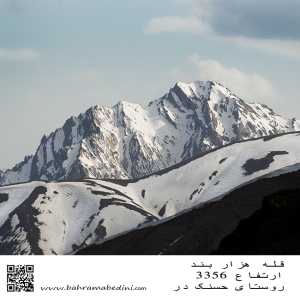
قله هزار بند در رشتهکوه البرز مرکزی و استان البرز قرار دارد. این قله با ارتفاع ۳۳۵۰ متر، به دلیل ساختار سنگی و صخرهای خود، نیاز به تجربه نسبی در کوهنوردی دارد. مسیر اصلی صعود از روستای حسنکدر شروع میشود و حدود ۵.۵ ساعت طول میکشد.
به این عکس امتیاز دهید.
این عکس توسط بهرام عابدینی از تپه ها و طبیعت اطراف این منطقه گرفته شده است. برای خرید این عکس یا عکس های دیگر از طریق وبسایت یا تلفن با ما تماس بگیرید.
Mount Hezarband is located in the central Alborz mountain range in Alborz Province. This peak, standing at 3,350 meters, is known for its rocky and rugged terrain, requiring some mountaineering experience. The main ascent route starts from the village of Hasanakdar and takes about 5.5 hours to reach the summit.
Literal translation of Hezarband means thousand shackles .
Please rate this picture.
This picture is taken by Bahram Abedini. If you want to purchase this picture or any other around this area please contact us through website, email or phone.
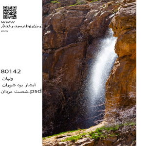
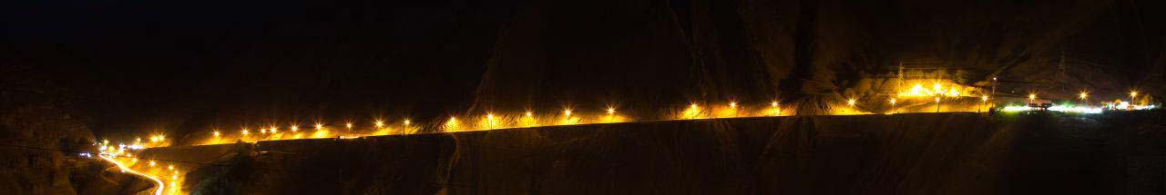
آبشار بره شوران که در رشتهکوههای البرز واقع شده، یکی از جاذبههای طبیعی زیبا است که در میان پوشش گیاهی انبوه و زمینهای ناهموار قرار دارد. این آبشار از ارتفاع قابل توجهی فرو میریزد و منظرهای خیرهکننده و صدای آرامشبخش آب جاری را ایجاد میکند. منطقه اطراف آبشار دارای تنوع زیستی غنی است و هوای خنک و تازهای دارد که آن را به مکانی ایدهآل برای یک سفر روزانه آرامشبخش تبدیل میکند. دسترسی به این آبشار معمولاً شامل یک پیادهروی از طریق مسیرهای دیدنی با چشماندازهای فوقالعاده از کوههای البرز است.
به این عکس امتیاز دهید.
این عکس توسط بهرام عابدینی از تپه ها و طبیعت اطراف این منطقه گرفته شده است. برای خرید این عکس یا عکس های دیگر از طریق وبسایت یا تلفن با ما تماس بگیرید.
English description:
Bareh Shooran Waterfall, located in the Alborz Mountains, is a beautiful natural attraction surrounded by lush greenery and rugged terrain. The waterfall cascades from a significant height, creating a mesmerizing sight and a soothing sound. The area is rich in biodiversity and offers a cool, refreshing atmosphere, making it ideal for a relaxing day trip. Access involves a scenic hike through trails with breathtaking views of the mountains.
Please rate this picture.
This picture is taken by Bahram Abedini. If you want to purchase this picture or any other around this area please contact us through website, email or phone.

آبشار کلشتر در جنوب غربی شهرستان رودبار و در روستای کلشتر واقع شده است. این آبشار با ارتفاع بیش از ۲۰ متر در میان جنگلهای انبوه قرار دارد و یکی از دیدنیترین آبشارهای گیلان است. برای رسیدن به آبشار، باید از جادههای محلی و جنگلی عبور کرده و حدود ۲۰ تا ۳۰ دقیقه پیادهروی کنید. بهترین زمان برای بازدید فصل بهار و تابستان است که هوا معتدل و طبیعت سرسبز است.
به این عکس امتیاز دهید.
این عکس توسط بهرام عابدینی از تپه ها و طبیعت اطراف این منطقه گرفته شده است. برای خرید این عکس یا عکس های دیگر از طریق وبسایت یا تلفن با ما تماس بگیرید.
English description:
Kalashter Waterfall is located in the southwest of Rudbar County, in the village of Kalashter. This waterfall, with a height of over 20 meters, is nestled among dense forests and is one of the most scenic waterfalls in Gilan Province. To reach the waterfall, you need to travel through local and forest roads and then walk for about 20 to 30 minutes. The best time to visit is during spring and summer when the weather is mild and the nature is lush and green.
Please rate this picture.
This picture is taken by Bahram Abedini. If you want to purchase this picture or any other around this area please contact us through website, email or phone.

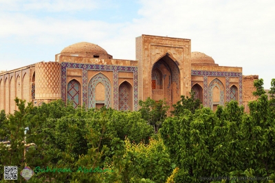
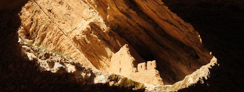
گورستان خالد نبی در شهرستان کلاله، استان گلستان، یکی از مکانهای تاریخی و اسرارآمیز ایران است. این گورستان در ارتفاعات کوه گوگجه داغ واقع شده و به دلیل سنگقبرهای منحصر به فرد و طراحیهای خاص، شهرت دارد. مقبره خالد نبی و آرامگاههای همراهانش، عالم بابا و چوپان آتا، در این مکان قرار دارند. بهترین زمان برای بازدید از این گورستان فصل بهار و اوایل تابستان است.
به عکس امتیاز دهید.
این عکس توسط بهرام عابدینی از تپه ها و طبیعت اطراف این منطقه گرفته شده است. برای خرید این عکس یا عکس های دیگر از طریق وبسایت یا تلفن با ما تماس بگیرید.
English description:
Khaled Nabi Cemetery is a historical site in Kalaleh County, Golestan Province, Iran, named after the prophet Khaled bin Sinan. Located on the Gokjeh Dagh mountain, it offers stunning views and features unique, ancient tombstones with intriguing designs. The site includes the shrine of Khaled Nabi and the tombs of his companions. The best time to visit is during spring and early summer when the weather is mild and the landscape is lush.
Please rate this picture.
This picture is taken by Bahram Abedini. If you want to purchase this picture or any other around this area please contact us through website, email or phone.
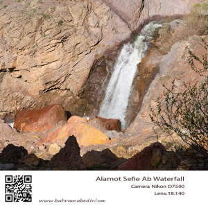
آبشار سفیدآب، واقع در استان لرستان ایران، یکی از جاذبههای طبیعی خیرهکننده است که در حدود ۵۰ کیلومتری جنوب شرقی الیگودرز قرار دارد. این آبشار با ارتفاع ۷۰ متر، به دلیل جریان قوی و مه سفید رنگی که ایجاد میکند، معروف است و در قلب رشتهکوههای زاگرس قرار دارد. منطقه اطراف آبشار دارای تنوع زیستی غنی است و شامل گونههای مختلف گیاهی و حیات وحش میشود. آبشار سفیدآب در هر فصل تجربهای منحصر به فرد ارائه میدهد، از جریان کامل در بهار تا تبدیل شدن به یک سرزمین عجایب یخزده در زمستان. این آبشار از طریق جادههای کوهستانی و یک پیادهروی متوسط قابل دسترسی است و مناظر خیرهکننده و محیطی آرام برای بازدیدکنندگان فراهم میکند.
به این عکس امتیاز دهید.
این عکس توسط بهرام عابدینی از تپه ها و طبیعت اطراف این منطقه گرفته شده است. برای خرید این عکس یا عکس های دیگر از طریق وبسایت یا تلفن با ما تماس بگیرید.
Sefid Aab Waterfall, located in Lorestan Province, Iran, is a stunning natural attraction about 50 kilometers southeast of Aligudarz. This 70-meter-high waterfall, known for its powerful flow and white mist, is nestled in the Zagros Mountains. The area is rich in biodiversity, featuring various plant species and wildlife. The waterfall offers a unique experience in each season, from the full flow in spring to a frozen wonderland in winter. Accessible via mountain roads and a moderate hike, it provides breathtaking scenery and a serene environment for visitors.
Please rate this picture.
This picture is taken by Bahram Abedini. If you want to purchase this picture or any other around this area please contact us through website, email or phone.
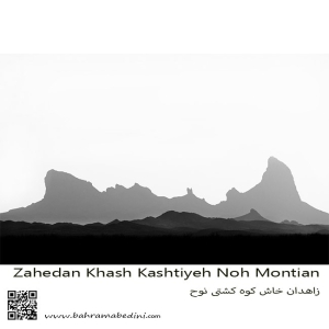
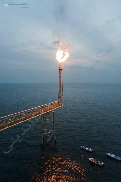
کوه تفتان، که به نام کوه کشتی نوح نیز شناخته میشود، یکی از مهمترین و مرتفعترین کوههای جنوب شرقی ایران است. این کوه در نزدیکی شهرستان خاش و در فاصله حدود ۱۰۰ کیلومتری از زاهدان قرار دارد. تفتان با ارتفاع ۳۹۴۱ متر از سطح دریا، به عنوان یک کوه آتشفشانی فعال شناخته میشود و دارای چهار قله اصلی به نامهای چهل تن، مادرکوه، صبح کوه و نرکوه است.
ویژگیهای برجسته کوه تفتان:
فعالیتهای آتشفشانی: تفتان به دلیل فعالیتهای آتشفشانی خود مشهور است و از دهانههای آن گازهای گوگردی به طور مداوم خارج میشود.
چشمههای آب معدنی: در اطراف کوه، چشمههای آب معدنی متعددی وجود دارد که به دلیل خواص درمانی خود، مورد توجه گردشگران و محلیها قرار گرفتهاند.
طبیعت بکر: مناظر طبیعی زیبا و بکر این منطقه، شامل پوشش گیاهی متنوع و حیات وحش غنی، این کوه را به مقصدی محبوب برای طبیعتگردان و کوهنوردان تبدیل کرده است.
مسیرهای کوهنوردی: مسیرهای مختلفی برای صعود به قلههای تفتان وجود دارد که هر کدام چالشها و زیباییهای خاص خود را دارند
به این عکس امتیاز دهید.
این عکس توسط بهرام عابدینی از تپه ها و طبیعت اطراف این منطقه گرفته شده است. برای خرید این عکس یا عکس های دیگر از طریق وبسایت یا تلفن با ما تماس بگیرید.
Mount Taftan, also known as Noah’s Ark Mountain, is one of the most significant and tallest mountains in southeastern Iran. Located near the city of Khash and about 100 kilometers from Zahedan, Taftan stands at an elevation of 3,941 meters above sea level and is known as an active volcanic mountain. It features four main peaks: Chehel Tan, Madar Kuh, Sobh Kuh, and Nar Kuh, from which sulfur gases continuously emit.