آخرین عکس های طبیعت و مناظر ایران
بهرام عابدینی
آخرین عکس های طبیعت و مناظر ایران
آخرین عکس های طبیعت و مناظر ایران
بهرام عابدینی
بهرام عابدینی
Website Language

")

Farsi Description:
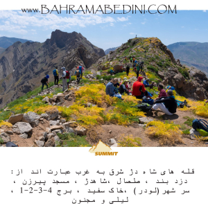
شاه دژ، دزدبند، صلصال، مسجد پیرزن، سر شهر (لودر)، خاک سفید، قلههای برج، و کوه لیلی و مجنون هر کدام دارای ویژگیهای خاص و تاریخی هستند. شاه دژ و قلههای برج در رشتهکوه البرز قرار دارند و به دلیل دیوارههای سنگی و چشماندازهای زیبا، مقصدی محبوب برای کوهنوردان هستند. دزدبند و صلصال قلعههای تاریخی با معماری خاص و موقعیت استراتژیک هستند. مسجد پیرزن در بوشهر توسط پیرزنی ساخته شده و برهسر در گیلان به دلیل طبیعت بکر و پوشش گیاهی انبوه، مقصدی محبوب برای گردشگران است. کوه سفید به دلیل معادن گچ خود معروف است و داستان عاشقانه لیلی و مجنون به کوه لیلی و مجنون اشاره دارد.
به این عکس امتیاز دهید.
این عکس توسط بهرام عابدینی از تپه ها و طبیعت اطراف این منطقه گرفته شده است. برای خرید این عکس یا عکس های دیگر از طریق وبسایت یا تلفن با ما تماس بگیرید.
توضیحات انگلیسی:
Shah Dej, Dozdband, Salsal, Masjed Pirzan, Sar Shahr (Loader), Khak Sefid, Borj Peaks, and Lili and Majnun Mountain each have unique historical and natural features. Shah Dej and Borj Peaks are located in the Alborz mountain range and are popular destinations for mountaineers due to their rocky walls and beautiful landscapes. Dozdband and Salsal are historical castles with distinctive architecture and strategic locations. Masjed Pirzan in Bushehr was built by an elderly woman, and Bareh Sar in Gilan is a popular tourist destination due to its pristine nature and dense vegetation. Khak Sefid is known for its gypsum mines, and the romantic story of Lili and Majnun is associated with Lili and Majnun Mountain.
Please rate this picture.
This picture is taken by Bahram Abedini. If you want to purchase this picture or any other around this area please contact us through website, email or phone.
We sell pictures digitally in Large format and internationally through secure paypal payment in the US.
Farsi Description:
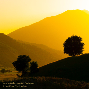
شولآباد یکی از روستاهای زیبای استان لرستان در ایران است. این روستا در منطقهای کوهستانی قرار دارد و طبیعت بکر و چشمنوازی دارد. مردم شولآباد عمدتاً به کشاورزی و دامداری مشغول هستند و محصولات محلی مانند گردو، بادام، و عسل تولید میکنند. همچنین، این منطقه به خاطر چشمههای آب معدنی و هوای پاک و دلپذیرش معروف است. اگر به دنبال مکانی آرام و دور از هیاهوی شهری هستید، شولآباد میتواند مقصدی عالی برای شما باشد.
به این عکس امتیاز دهید.
این عکس توسط بهرام عابدینی از تپه ها و طبیعت اطراف این منطقه گرفته شده است. برای خرید این عکس یا عکس های دیگر از طریق وبسایت یا تلفن با ما تماس بگیرید.
توضیحات انگلیسی:
Shul Abad is a beautiful village located in the Lorestan province of Iran. Nestled in a mountainous region, it boasts stunning natural scenery. The residents of Shul Abad primarily engage in agriculture and livestock farming, producing local products such as walnuts, almonds, and honey. The area is also known for its mineral springs and clean, pleasant air. If you're looking for a peaceful place away from the hustle and bustle of city life, Shul Abad could be an excellent destination for you.
Please rate this picture.
This picture is taken by Bahram Abedini. If you want to purchase this picture or any other around this area please contact us through website, email or phone.
We sell pictures digitally in Large format and internationally through secure paypal payment in the US.
Farsi Description:
سپید دشت یکی از مناطق زیبا و دیدنی استان لرستان در ایران است. این منطقه به خاطر طبیعت بکر و مناظر طبیعی خیرهکنندهاش شناخته میشود. سپید دشت دارای کوهها، جنگلها و رودخانههای فراوانی است که آن را به مقصدی محبوب برای طبیعتگردان و علاقهمندان به ماجراجویی تبدیل کرده است. همچنین، این منطقه دارای آب و هوای معتدل و دلپذیری است که در فصول مختلف سال جذابیت خاصی به آن میبخشد.
به این عکس امتیاز دهید.
این عکس توسط بهرام عابدینی از تپه ها و طبیعت اطراف این منطقه گرفته شده است. برای خرید این عکس یا عکس های دیگر از طریق وبسایت یا تلفن با ما تماس بگیرید.
توضیحات انگلیسی:
Sepid Dasht is one of the beautiful and scenic areas in Lorestan province, Iran. This region is known for its pristine nature and stunning landscapes. Sepid Dasht features mountains, forests, and numerous rivers, making it a popular destination for nature enthusiasts and adventure seekers. Additionally, the area enjoys a mild and pleasant climate, adding to its charm throughout the year.
Please rate this picture.
This picture is taken by Bahram Abedini. If you want to purchase this picture or any other around this area please contact us through website, email or phone.

Farsi Description:
آبشار چم چیت، که به نام آبشار آبگرمه نیز شناخته میشود، یکی از جاذبههای طبیعی زیبا در استان لرستان است. این آبشار در نزدیکی روستای چم چیت و در مسیر رودخانه سزار قرار دارد.
آبشار چم چیت با ارتفاع بیش از ۲۰ متر و عرض تاج ۱۰ متر، در میان پوششهای گیاهی متراکم و طبیعت بکر منطقه جاری است. این آبشار به دلیل نزدیکی به آبشار مشهور بیشه کمتر شناخته شده است، اما زیبایی خاص خود را دارد و در تمام فصول سال جذابیتهای ویژهای ارائه میدهد.
برای رسیدن به این آبشار، میتوانید از مسیرهای ریلی و آسفالته استفاده کنید. مسیر ریلی از راهآهن تهران-خوزستان و بین ایستگاههای قارون و بیشه میگذرد.
به این عکس امتیاز دهید.
این عکس توسط بهرام عابدینی از تپه ها و طبیعت اطراف این منطقه گرفته شده است. برای خرید این عکس یا عکس های دیگر از طریق وبسایت یا تلفن با ما تماس بگیرید.
توضیحات انگلیسی:
Cham Chit Waterfall, also known as Abgarmeh Waterfall, is one of the beautiful natural attractions in Lorestan Province. This waterfall is located near the village of Cham Chit and along the Sezar River.
Cham Chit Waterfall, with a height of over 20 meters and a crown width of 10 meters, flows amidst dense vegetation and pristine nature. Due to its proximity to the famous Bisheh Waterfall, it is less known but has its own unique beauty and offers special attractions in all seasons.
To reach this waterfall, you can use both rail and asphalt routes. The rail route passes through the Tehran-Khuzestan railway and between the stations of Qarun and Bisheh.
Please rate this picture.
This picture is taken by Bahram Abedini. If you want to purchase this picture or any other around this area please contact us through website, email or phone.

Farsi Description:
کویر لوت یکی از شگفتانگیزترین مناطق طبیعی ایران است و در فروردین 1403 میزبان گردشگران و طبیعتدوستان خواهد بود. جاده شهداد به نهبندان، که از دل این کویر میگذرد، یکی از مسیرهای محبوب برای سفر به این منطقه است.
در این سفر، میتوانید از کلوتهای شهداد بازدید کنید. کلوتها، برجستگیهای شنی عظیمی هستند که در اثر فرسایش باد و آب به وجود آمدهاند و یکی از زیباترین مناظر طبیعی ایران را تشکیل میدهند. این منطقه به دلیل زیبایی بینظیر و شرایط خاص جغرافیایی، در فهرست آثار ملی ایران و میراث جهانی یونسکو به ثبت رسیده است.
در طول این سفر، میتوانید از جاذبههای تاریخی منطقه شهداد نیز بازدید کنید و از نخلستانها و رود شور که تنها رود دائمی در اعماق کویر لوت است، دیدن کنید. همچنین، تجربه شبنشینی و رصد آسمان پرستاره کویر و بازدید از آبشار کشیت، از دیگر جاذبههای این سفر خواهد بود.
به این عکس امتیاز دهید.
این عکس توسط بهرام عابدینی از تپه ها و طبیعت اطراف این منطقه گرفته شده است. برای خرید این عکس یا عکس های دیگر از طریق وبسایت یا تلفن با ما تماس بگیرید.
توضیحات انگلیسی:
The Lut Desert, one of Iran's most astonishing natural areas, will welcome tourists and nature enthusiasts in April 2024. The road from Shahdad to Nehbandan, which passes through this desert, is a popular route for traveling to this region.
During this trip, you can visit the Shahdad Kaluts. These massive sand formations, created by wind and water erosion, are among the most beautiful natural landscapes in Iran. Due to its unique beauty and geographical conditions, this area is listed as a national heritage site in Iran and a UNESCO World Heritage site.
Throughout this journey, you can also explore the historical attractions of the Shahdad region, visit the palm groves, and see the Shur River, the only permanent river in the depths of the Lut Desert. Additionally, experiencing a night under the starry desert sky and visiting the Keshit Waterfall are other highlights of this trip.
Please rate this picture.
This picture is taken by Bahram Abedini. If you want to purchase this picture or any other around this area please contact us through website, email or phone.
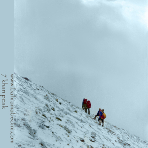
Farsi Description:
قله هفت خوان یکی از قلل زیبای رشتهکوه البرز غربی است که در نزدیکی روستای سپهسالار قرار دارد و ارتفاع آن به ۳۹۷۰ متر میرسد. در زمستان سال ۱۳۵۹، صعود به این قله به دلیل شرایط سخت آب و هوایی و برف سنگین، چالشی بزرگ برای کوهنوردان بود.
در آن سال، گروهی از کوهنوردان با تجهیزات محدود و بدون امکانات پیشرفته امروزی، تصمیم به صعود به قله هفت خوان گرفتند. مسیر صعود از روستای سپهسالار آغاز شد و کوهنوردان با عبور از یال جنوبی و گردنه خرگوش، به سمت قله حرکت کردند. شرایط سخت زمستانی، از جمله برف سنگین و بادهای شدید، این صعود را بسیار دشوار کرد.
با وجود این چالشها، کوهنوردان با تلاش و پشتکار فراوان توانستند به قله برسند و این صعود به عنوان یکی از دستاوردهای مهم کوهنوردی در آن زمان به شمار میرفت. این صعود نشاندهنده اراده و عزم راسخ کوهنوردان در مواجهه با شرایط سخت طبیعی بود.
به این عکس امتیاز دهید.
این عکس توسط بهرام عابدینی از تپه ها و طبیعت اطراف این منطقه گرفته شده است. برای خرید این عکس یا عکس های دیگر از طریق وبسایت یا تلفن با ما تماس بگیرید.
توضیحات انگلیسی:
Mount Haft Khān is one of the beautiful peaks of the western Alborz mountain range, located near the village of Sepahsalar, with an elevation of 3,970 meters (13,024.93 feet.). In the winter of 1980, climbing this peak was a significant challenge for mountaineers due to harsh weather conditions and heavy snowfall.
That year, a group of mountaineers, with limited equipment and without the advanced facilities available today, decided to climb Mount Haft Khān. The ascent route started from the village of Sepahsalar, and the climbers moved towards the peak by passing through the southern ridge and Kharghosh Pass. The harsh winter conditions, including heavy snow and strong winds, made this climb very difficult.
Despite these challenges, the mountaineers, with great effort and perseverance, managed to reach the summit. This climb was considered one of the significant achievements in mountaineering at that time. It demonstrated the determination and strong will of mountaineers in facing tough natural conditions.
Please rate this picture.
This picture is taken by Bahram Abedini. If you want to purchase this picture or any other around this area please contact us through website, email or phone.
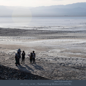
Farsi Description:
تالاب کجی نمکزار در نزدیکی نهبندان، خراسان جنوبی، با وسعت ۲۲۷۶۵ هکتار، زیستگاه پرندگان مهاجر و بومی متعددی است. این تالاب به دلیل املاح معدنی موجود در آب، خواص درمانی دارد و زیستگاه گونههای مختلف پستانداران نیز میباشد.
به این عکس امتیاز دهید.
این عکس توسط بهرام عابدینی از تپه ها و طبیعت اطراف این منطقه گرفته شده است. برای خرید این عکس یا عکس های دیگر از طریق وبسایت یا تلفن با ما تماس بگیرید.
توضیحات انگلیسی:
Kajeh Namakzar Wetland, located near Nehbandan in South Khorasan, spans 22,765 hectares and is a habitat for numerous migratory and native birds. The wetland's mineral-rich waters have therapeutic properties, and it is also home to various mammal species.
Please rate this picture.
This picture is taken by Bahram Abedini. If you want to purchase this picture or any other around this area please contact us through website, email or phone.
Farsi Description:
به این عکس امتیاز دهید.
این عکس توسط بهرام عابدینی از تپه ها و طبیعت اطراف این منطقه گرفته شده است. برای خرید این عکس یا عکس های دیگر از طریق وبسایت یا تلفن با ما تماس بگیرید.
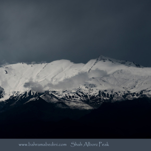
قله شاه البرز با ارتفاع ۴۱۷۰ متر، در مرز استانهای البرز و قزوین قرار دارد و مرز طبیعی بین دره طالقان و دره الموت است. این قله دارای پنج قله فرعی بالای ۴۰۰۰ متر است و مسیرهای صعود آن از روستاهای حسنجون، هرنج و سی چشمه در طالقان و جاده الموت انجام میشود. شاه البرز به دلیل چشماندازهای زیبا و طبیعت بکر، مقصد محبوبی برای کوهنوردان است.
توضیحات انگلیسی:
Please rate this picture.
This picture is taken by Bahram Abedini. If you want to purchase this picture or any other around this area please contact us through website, email or phone.
Shah Alborz Peak, standing at 4,170 meters, is located on the border of Alborz and Qazvin provinces, forming a natural boundary between Taleghan Valley and Alamut Valley. It has five subsidiary peaks over 4,000 meters. The ascent routes typically start from the villages of Hasanjoon, Haranj, and Si Cheshmeh in Taleghan, as well as from the Alamut road. Due to its beautiful landscapes and pristine nature, Shah Alborz is a popular destination for mountaineers.

Farsi Description:
کوههای مریخی نهبندان، که به کوههای مینیاتوری نیز معروف هستند، در نزدیکی شهر نهبندان در استان خراسان جنوبی قرار دارند. این کوهها به دلیل شکلهای غیرعادی خود شبیه به سطح مریخ به نظر میرسند و یکی از جاذبههای طبیعی منطقه محسوب میشوند.
به این عکس امتیاز دهید.
این عکس توسط بهرام عابدینی از تپه ها و طبیعت اطراف این منطقه گرفته شده است. برای خرید این عکس یا عکس های دیگر از طریق وبسایت یا تلفن با ما تماس بگیرید.
توضیحات انگلیسی:
The Martian Mountains of Nehbandan, also known as the Miniature Mountains, are located near the city of Nehbandan in South Khorasan Province. These mountains resemble the surface of Mars due to their unusual and jagged shapes, making them a unique natural attraction in the region.
Please rate this picture.
This picture is taken by Bahram Abedini. If you want to purchase this picture or any other around this area please contact us through website, email or phone.

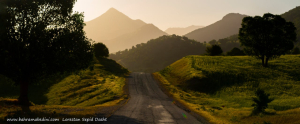
Farsi Description:
جادههای پاییزی در میان کوهها با برگهای رنگارنگ و مناظر کوهستانی، یکی از زیباترین مناظر طبیعی را به نمایش میگذارند. جادههایی مانند چالوس، هراز، و سنندج-مریوان با مناظر جنگلی و هوای خنک پاییزی، تجربهای فراموشنشدنی برای مسافران فراهم میکنند.
به این عکس امتیاز دهید.
این عکس توسط بهرام عابدینی از تپه ها و طبیعت اطراف این منطقه گرفته شده است. برای خرید این عکس یا عکس های دیگر از طریق وبسایت یا تلفن با ما تماس بگیرید.
توضیحات انگلیسی:
Autumn roads through the mountains showcase some of the most beautiful natural scenery. With colorful leaves and mountainous landscapes, roads like Chalous, Haraz, and Sanandaj-Marivan offer unforgettable experiences for travelers. The vibrant foliage and cool autumn air make these journeys even more enjoyable.
Please rate this picture.
This picture is taken by Bahram Abedini. If you want to purchase this picture or any other around this area please contact us through website, email or phone.