آخرین عکس های طبیعت و مناظر ایران
بهرام عابدینی
آخرین عکس های طبیعت و مناظر ایران
آخرین عکس های طبیعت و مناظر ایران
بهرام عابدینی
بهرام عابدینی
Website Language

")

Farsi Description:
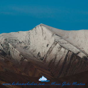
قله منا ر و گلوی به ارتفاع تقریبی سه وهزارو پانصد متر در شمال روستای واریان وجنوب شرقی روستای مورودقرار دارد این دوقله در خطالراس سیاه سنگ منار و گلوی و گلو سربند واقع است راه صعود به قله بیشتر از روستای مورود است آبشار های که از قله ها سرازیر می شود یکی آبشا ر چهار صد تنور در جنوب و آبشار رفک در شمال این کوه قرار دارد.
به این عکس امتیاز دهید.
این عکس توسط بهرام عابدینی از تپه ها و طبیعت اطراف این منطقه گرفته شده است. برای خرید این عکس یا عکس های دیگر از طریق وبسایت یا تلفن با ما تماس بگیرید.
توضیحات انگلیسی:
Please rate this picture.
The peaks of Manar and Golou, with an approximate height of 3,500 meters, are located north of the village of Varyan and southeast of the village of Moroud. These two peaks are situated on the ridge of Siah Sang Manar and Golou and Golou Sarband. The main route to ascend the peaks is from the village of Moroud. The waterfalls that flow from the peaks include the Four Hundred Tanur waterfall in the south and the Rafak waterfall in the north of this mountain."
This picture is taken by Bahram Abedini. If you want to purchase this picture or any other around this area please contact us through website, email or phone.
We sell pictures digitally in Large format and internationally through secure paypal payment in the US.
Farsi Description:
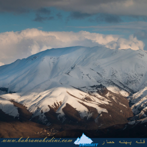
کوه پهنه حصار یک قله برجسته در کوههای البرز مرکزی در شمال ایران، نزدیک روستای سنگان بالا است. این کوه به خاطر مسیرهای دیدنی، مناظر متنوع و تنوع زیستی غنی خود شناخته شده است. این منطقه شامل آبشار چشمگیر سنگان نیز میشود که آن را به مقصدی محبوب برای کوهنوردان و علاقهمندان به طبیعت تبدیل کرده است.
به این عکس امتیاز دهید.
این عکس توسط بهرام عابدینی از تپه ها و طبیعت اطراف این منطقه گرفته شده است. برای خرید این عکس یا عکس های دیگر از طریق وبسایت یا تلفن با ما تماس بگیرید.
توضیحات انگلیسی:
The Mountain of Pahne Hesar is a prominent peak in the Central Alborz Mountains of northern Iran, near the village of Sangan Bala. It's known for its scenic trails, diverse landscapes, and rich biodiversity. The area includes the impressive Sangan Waterfall, making it a popular destination for hikers and nature enthusiasts.
Please rate this picture.
This picture is taken by Bahram Abedini. If you want to purchase this picture or any other around this area please contact us through website, email or phone.
We sell pictures digitally in Large format and internationally through secure paypal payment in the US.
Farsi Description:
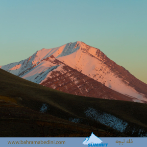
قله لیچه به ارتفاع 2900 در استان البرز در شرق روستای کندور و در غرب روستای واریش تهران قرار دارد مسیرهای صعود روستای کندور و روستای واریش میباشد لیچه همجوار با کوه چشمه شاهی ودر ادامه یال به قله لیز و لیزان متصل می شود ارتفاع قله 2900 متر واین عکس از جاده قدیم کندور زیر قله پورا گرفته شده
به این عکس امتیاز دهید.
این عکس توسط بهرام عابدینی از تپه ها و طبیعت اطراف این منطقه گرفته شده است. برای خرید این عکس یا عکس های دیگر از طریق وبسایت یا تلفن با ما تماس بگیرید.
توضیحات انگلیسی:
"Liche Peak, with an elevation of 2900 meters, is located in Alborz Province, east of Kondor village and west of Varish village in Tehran. The ascent routes are from Kondor village and Varish village. Liche is adjacent to Cheshmeh Shahi mountain and continues along the ridge to connect to Liz and Lizan peaks. The elevation of the peak is 2900 meters, and this photo was taken from the old Kondor road below Pura Peak."
Please rate this picture.
This picture is taken by Bahram Abedini. If you want to purchase this picture or any other around this area please contact us through website, email or phone.
We sell pictures digitally in Large format and internationally through secure paypal payment in the US.
Farsi Description:
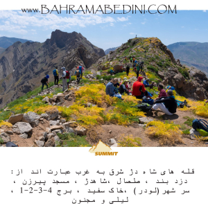
شاه دژ، دزدبند، صلصال، مسجد پیرزن، سر شهر (لودر)، خاک سفید، قلههای برج، و کوه لیلی و مجنون هر کدام دارای ویژگیهای خاص و تاریخی هستند. شاه دژ و قلههای برج در رشتهکوه البرز قرار دارند و به دلیل دیوارههای سنگی و چشماندازهای زیبا، مقصدی محبوب برای کوهنوردان هستند. دزدبند و صلصال قلعههای تاریخی با معماری خاص و موقعیت استراتژیک هستند. مسجد پیرزن در بوشهر توسط پیرزنی ساخته شده و برهسر در گیلان به دلیل طبیعت بکر و پوشش گیاهی انبوه، مقصدی محبوب برای گردشگران است. کوه سفید به دلیل معادن گچ خود معروف است و داستان عاشقانه لیلی و مجنون به کوه لیلی و مجنون اشاره دارد.
به این عکس امتیاز دهید.
این عکس توسط بهرام عابدینی از تپه ها و طبیعت اطراف این منطقه گرفته شده است. برای خرید این عکس یا عکس های دیگر از طریق وبسایت یا تلفن با ما تماس بگیرید.
توضیحات انگلیسی:
Shah Dej, Dozdband, Salsal, Masjed Pirzan, Sar Shahr (Loader), Khak Sefid, Borj Peaks, and Lili and Majnun Mountain each have unique historical and natural features. Shah Dej and Borj Peaks are located in the Alborz mountain range and are popular destinations for mountaineers due to their rocky walls and beautiful landscapes. Dozdband and Salsal are historical castles with distinctive architecture and strategic locations. Masjed Pirzan in Bushehr was built by an elderly woman, and Bareh Sar in Gilan is a popular tourist destination due to its pristine nature and dense vegetation. Khak Sefid is known for its gypsum mines, and the romantic story of Lili and Majnun is associated with Lili and Majnun Mountain.
Please rate this picture.
This picture is taken by Bahram Abedini. If you want to purchase this picture or any other around this area please contact us through website, email or phone.
We sell pictures digitally in Large format and internationally through secure paypal payment in the US.
Farsi Description:
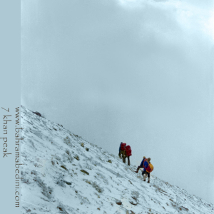
قله هفت خوان یکی از قلل زیبای رشتهکوه البرز غربی است که در نزدیکی روستای سپهسالار قرار دارد و ارتفاع آن به ۳۹۷۰ متر میرسد. در زمستان سال ۱۳۵۹، صعود به این قله به دلیل شرایط سخت آب و هوایی و برف سنگین، چالشی بزرگ برای کوهنوردان بود.
در آن سال، گروهی از کوهنوردان با تجهیزات محدود و بدون امکانات پیشرفته امروزی، تصمیم به صعود به قله هفت خوان گرفتند. مسیر صعود از روستای سپهسالار آغاز شد و کوهنوردان با عبور از یال جنوبی و گردنه خرگوش، به سمت قله حرکت کردند. شرایط سخت زمستانی، از جمله برف سنگین و بادهای شدید، این صعود را بسیار دشوار کرد.
با وجود این چالشها، کوهنوردان با تلاش و پشتکار فراوان توانستند به قله برسند و این صعود به عنوان یکی از دستاوردهای مهم کوهنوردی در آن زمان به شمار میرفت. این صعود نشاندهنده اراده و عزم راسخ کوهنوردان در مواجهه با شرایط سخت طبیعی بود.
به این عکس امتیاز دهید.
این عکس توسط بهرام عابدینی از تپه ها و طبیعت اطراف این منطقه گرفته شده است. برای خرید این عکس یا عکس های دیگر از طریق وبسایت یا تلفن با ما تماس بگیرید.
توضیحات انگلیسی:
Mount Haft Khān is one of the beautiful peaks of the western Alborz mountain range, located near the village of Sepahsalar, with an elevation of 3,970 meters (13,024.93 feet.). In the winter of 1980, climbing this peak was a significant challenge for mountaineers due to harsh weather conditions and heavy snowfall.
That year, a group of mountaineers, with limited equipment and without the advanced facilities available today, decided to climb Mount Haft Khān. The ascent route started from the village of Sepahsalar, and the climbers moved towards the peak by passing through the southern ridge and Kharghosh Pass. The harsh winter conditions, including heavy snow and strong winds, made this climb very difficult.
Despite these challenges, the mountaineers, with great effort and perseverance, managed to reach the summit. This climb was considered one of the significant achievements in mountaineering at that time. It demonstrated the determination and strong will of mountaineers in facing tough natural conditions.
Please rate this picture.
This picture is taken by Bahram Abedini. If you want to purchase this picture or any other around this area please contact us through website, email or phone.
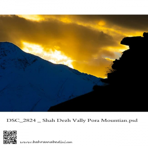
The valley of Shah dej in a sunset
This picture has been taken on my recent hiking in the region , the summit in the picture is the Poora peak
دره شاه دژ و قله پورا در پس زمینه
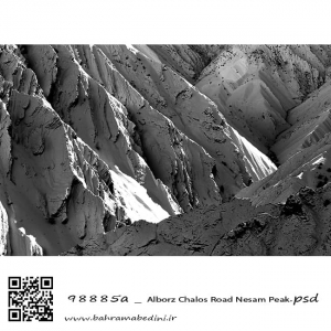
Alborz mountain, The summit of Nesam. A black and white abstract photography
کوه های آزاد کوه ، قله نسام. عکسی سیاه و سفید از طبیعت ایران
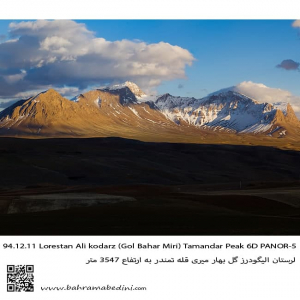
This is western Iran on the mountain range of Alborz. The summit is called Tamandar and is in city of Aligoodarz in province of Lorestan.
قله تمندر در شهر لرستان و منطقه گل بهار میری . در استان لرستان.
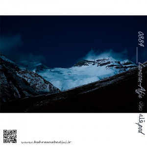
عکسی از قله ریزان در شب.
این کوه در بالای دشت هویج و دشت گردو در منطقه فشم واقع است. قله ای بلند و نه چندان دشوار برای صعود است. شب ها معمولاً در این منطقه کوهنوردهای زیادی میمانند تا به صعود به یکی از قلل این منطقه عازم شوند.
Central Alborz is home for many high summits. one of these mountains is Rizan. literally Rizan derive from the word pour, or flow and it indicates to the pouring of small pebbles from a mountain. Another meaning of Rizan as a form of Riz is small which I don't believe would be the case for this grand mountain.
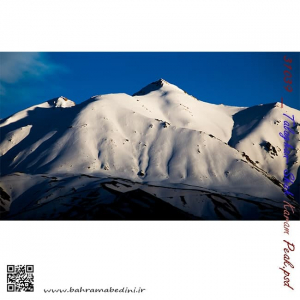
Shah Karam mountain
in the region of Taleghan, north central Iran
طالقان خچیره قله شاه کرم
عظمت و بزرگی کوه های ایران بسیار چشمگیر و زیبا هست و برف این زیبایی را دو چندان میکند. طالقان جزء روستاهایی هست که دور تا دور آن را کوه محاصره کرده و منطقه کوهستانی زیبایی رو به وجود آورده است.
برای خرید این عکس یا دیگر عکس های با ما تماس بگیرید.