آخرین عکس های طبیعت و مناظر ایران
بهرام عابدینی
آخرین عکس های طبیعت و مناظر ایران
آخرین عکس های طبیعت و مناظر ایران
بهرام عابدینی
بهرام عابدینی
Website Language

")

Farsi Description:
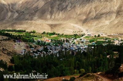
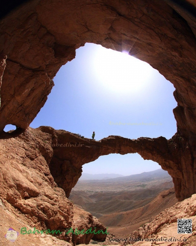
قله منا ر و گلوی به ارتفاع تقریبی سه وهزارو پانصد متر در شمال روستای واریان وجنوب شرقی روستای مورودقرار دارد این دوقله در خطالراس سیاه سنگ منار و گلوی و گلو سربند واقع است راه صعود به قله بیشتر از روستای مورود است آبشار های که از قله ها سرازیر می شود یکی آبشا ر چهار صد تنور در جنوب و آبشار رفک در شمال این کوه قرار دارد.
به این عکس امتیاز دهید.
این عکس توسط بهرام عابدینی از تپه ها و طبیعت اطراف این منطقه گرفته شده است. برای خرید این عکس یا عکس های دیگر از طریق وبسایت یا تلفن با ما تماس بگیرید.
توضیحات انگلیسی:
Please rate this picture.
The peaks of Manar and Golou, with an approximate height of 3,500 meters, are located north of the village of Varyan and southeast of the village of Moroud. These two peaks are situated on the ridge of Siah Sang Manar and Golou and Golou Sarband. The main route to ascend the peaks is from the village of Moroud. The waterfalls that flow from the peaks include the Four Hundred Tanur waterfall in the south and the Rafak waterfall in the north of this mountain."
This picture is taken by Bahram Abedini. If you want to purchase this picture or any other around this area please contact us through website, email or phone.
We sell pictures digitally in Large format and internationally through secure paypal payment in the US.
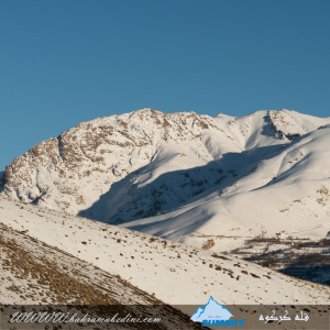
Farsi Description:
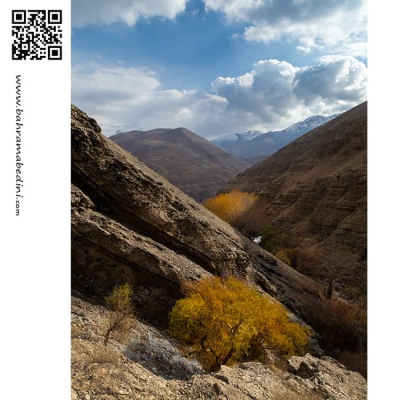
قلهٔ کرکوه با ارتفاع ۳۱۰۰ متر در درهٔ خور و سیجان واقع شده است. این قله با قلههای پهنهحصار و چال ناجی یال مشترک دارد و آبشارهای زیبای پنجهپلنگ و رفک در دامنههای آن قرار گرفتهاند. منطقهٔ کرکوه با طبیعت بکر، پوشش گیاهی متنوع و چشماندازهای کوهستانی، یکی از مقاصد محبوب کوهنوردان و طبیعتگردان در نزدیکی تهران به شمار میرود.
به این عکس امتیاز دهید.
این عکس توسط بهرام عابدینی از تپه ها و طبیعت اطراف این منطقه گرفته شده است. برای خرید این عکس یا عکس های دیگر از طریق وبسایت یا تلفن با ما تماس بگیرید.
توضیحات انگلیسی:
Mount Karkouh, standing at an elevation of 3,100 meters, is located in the Khur and Sijan valley. It shares a ridge with the peaks of Pahneh Hisar and Chal Naji, and the beautiful waterfalls of Panjeh Palang and Rafak lie at its base. The Karkouh region, with its pristine nature, diverse vegetation, and stunning mountain landscapes, is a popular destination for hikers and nature enthusiasts near Tehran.
Please rate this picture.
This picture is taken by Bahram Abedini. If you want to purchase this picture or any other around this area please contact us through website, email or phone.
We sell pictures digitally in Large format and internationally through secure paypal payment in the US.
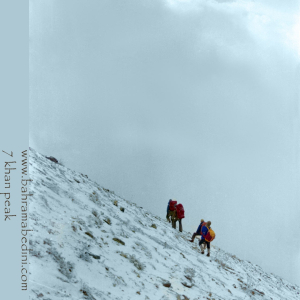
Farsi Description:
قله هفت خوان یکی از قلل زیبای رشتهکوه البرز غربی است که در نزدیکی روستای سپهسالار قرار دارد و ارتفاع آن به ۳۹۷۰ متر میرسد. در زمستان سال ۱۳۵۹، صعود به این قله به دلیل شرایط سخت آب و هوایی و برف سنگین، چالشی بزرگ برای کوهنوردان بود.
در آن سال، گروهی از کوهنوردان با تجهیزات محدود و بدون امکانات پیشرفته امروزی، تصمیم به صعود به قله هفت خوان گرفتند. مسیر صعود از روستای سپهسالار آغاز شد و کوهنوردان با عبور از یال جنوبی و گردنه خرگوش، به سمت قله حرکت کردند. شرایط سخت زمستانی، از جمله برف سنگین و بادهای شدید، این صعود را بسیار دشوار کرد.
با وجود این چالشها، کوهنوردان با تلاش و پشتکار فراوان توانستند به قله برسند و این صعود به عنوان یکی از دستاوردهای مهم کوهنوردی در آن زمان به شمار میرفت. این صعود نشاندهنده اراده و عزم راسخ کوهنوردان در مواجهه با شرایط سخت طبیعی بود.
به این عکس امتیاز دهید.
این عکس توسط بهرام عابدینی از تپه ها و طبیعت اطراف این منطقه گرفته شده است. برای خرید این عکس یا عکس های دیگر از طریق وبسایت یا تلفن با ما تماس بگیرید.
توضیحات انگلیسی:
Mount Haft Khān is one of the beautiful peaks of the western Alborz mountain range, located near the village of Sepahsalar, with an elevation of 3,970 meters (13,024.93 feet.). In the winter of 1980, climbing this peak was a significant challenge for mountaineers due to harsh weather conditions and heavy snowfall.
That year, a group of mountaineers, with limited equipment and without the advanced facilities available today, decided to climb Mount Haft Khān. The ascent route started from the village of Sepahsalar, and the climbers moved towards the peak by passing through the southern ridge and Kharghosh Pass. The harsh winter conditions, including heavy snow and strong winds, made this climb very difficult.
Despite these challenges, the mountaineers, with great effort and perseverance, managed to reach the summit. This climb was considered one of the significant achievements in mountaineering at that time. It demonstrated the determination and strong will of mountaineers in facing tough natural conditions.
Please rate this picture.
This picture is taken by Bahram Abedini. If you want to purchase this picture or any other around this area please contact us through website, email or phone.
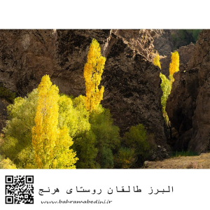
Farsi Description:
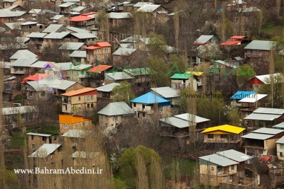
روستای هرنج در طالقان، استان البرز، در ارتفاع ۲۱۴۰ متری قرار دارد و به دلیل طبیعت بکر و محصولات کشاورزی متنوع معروف است. در پاییز، این روستا با رنگهای زنده قرمز، نارنجی و زرد، منظرهای خیرهکننده ایجاد میکند و هوای خنک و خشخش برگها تجربهای دلپذیر برای بازدیدکنندگان فراهم میکند.
به این عکس امتیاز دهید.
این عکس توسط بهرام عابدینی از تپه ها و طبیعت اطراف این منطقه گرفته شده است. برای خرید این عکس یا عکس های دیگر از طریق وبسایت یا تلفن با ما تماس بگیرید.
توضیحات انگلیسی:
Haranj village in Taleqan, Alborz Province, is situated at an elevation of 2,140 meters and is known for its pristine nature and diverse agricultural products. In autumn, the village transforms into a breathtaking scene with vibrant red, orange, and yellow colors. The cool air and the rustling of leaves create a pleasant experience for visitors.
Please rate this picture.
This picture is taken by Bahram Abedini. If you want to purchase this picture or any other around this area please contact us through website, email or phone.
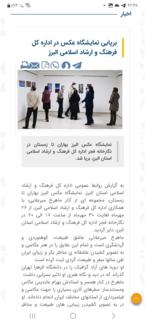
نمایشگاه عکس البرز بهاران تا زمستان در نگارخانه فجر اداره کل فرهنگ و ارشاد اسلامی استان البرز، برپا شد
در این نمایشگاه آثاری منتخب از عکاسی های طبیعت ماهرخ میرعلائی به معرض دید عموم قرار گرفت.
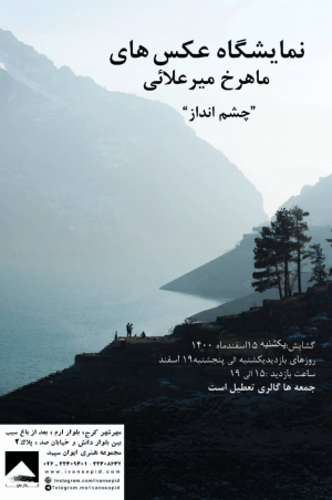
نمایشگاه عکس با عنوان چشم انداز در مجموعه هنری ایوان سپید برگزار میشود.
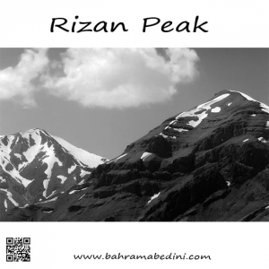
قله ریزان همراه با آتشکوه
The mountain of Rizan on the right and Atashkooh mountain on the left in black and white
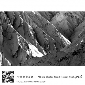
Alborz mountain, The summit of Nesam. A black and white abstract photography
کوه های آزاد کوه ، قله نسام. عکسی سیاه و سفید از طبیعت ایران
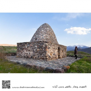
Stone cottage of Hasan Abaad
In the city if Alamoot , province of Qazvin, Iran
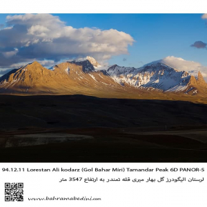
This is western Iran on the mountain range of Alborz. The summit is called Tamandar and is in city of Aligoodarz in province of Lorestan.
قله تمندر در شهر لرستان و منطقه گل بهار میری . در استان لرستان.