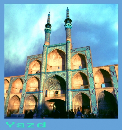
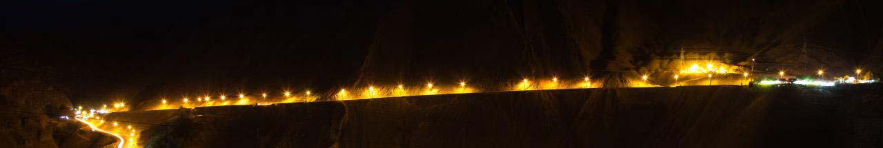
آخرین عکس های طبیعت و مناظر ایران
بهرام عابدینی
آخرین عکس های طبیعت و مناظر ایران
آخرین عکس های طبیعت و مناظر ایران
بهرام عابدینی
بهرام عابدینی
Website Language

")

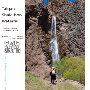
آبشار شاله بن یکی از زیباترین و بکرترین آبشارهای منطقه طالقان در استان البرز ایران است. این آبشار از قلل خسبان سرچشمه میگیرد و سپس به رودخانه خسبان رود میریزد. آبشار شاله بن در غرب روستای بزج و در حدود ۱۰ کیلومتری شمال شهرک طالقان واقع شده است.
مناظر طبیعی اطراف این آبشار بسیار چشمنواز و دلانگیز است و به عنوان یکی از جاذبههای گردشگری محبوب در طالقان شناخته میشود. طبیعت بکر و ناب این منطقه، آن را به مکانی ایدهآل برای علاقهمندان به طبیعتگردی و عکاسی تبدیل کرده است.
به این عکس امتیاز دهید.
این عکس توسط بهرام عابدینی از تپه ها و طبیعت اطراف این منطقه گرفته شده است. برای خرید این عکس یا عکس های دیگر از طریق وبسایت یا تلفن با ما تماس بگیرید.
English description:
Shaleh Bon Waterfall is one of the most beautiful and pristine waterfalls in the Taleghan region of Alborz Province, Iran. This waterfall originates from the Khesban peaks and flows into the Khesban River. It is located to the west of the village of Bozaj and about 10 kilometers north of Taleghan town.
The waterfall is composed of three tiers and has a height of approximately 25 meters. The access route to the waterfall passes through the villages of Khesban and Bozaj, both of which feature stunning natural landscapes and lush gardens. Along the way, you can also visit the Bozaj Cave, which has a depth of about 25 meters.
The best time to visit Shaleh Bon Waterfall is during the spring and summer seasons when the waterfall is more voluminous and the weather is milder. In winter, due to snow and ice, visiting this area can be challenging.
Please rate this picture.
This picture is taken by Bahram Abedini. If you want to purchase this picture or any other around this area please contact us through website, email or phone.
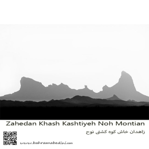
کوه تفتان، که به نام کوه کشتی نوح نیز شناخته میشود، یکی از مهمترین و مرتفعترین کوههای جنوب شرقی ایران است. این کوه در نزدیکی شهرستان خاش و در فاصله حدود ۱۰۰ کیلومتری از زاهدان قرار دارد. تفتان با ارتفاع ۳۹۴۱ متر از سطح دریا، به عنوان یک کوه آتشفشانی فعال شناخته میشود و دارای چهار قله اصلی به نامهای چهل تن، مادرکوه، صبح کوه و نرکوه است.
ویژگیهای برجسته کوه تفتان:
فعالیتهای آتشفشانی: تفتان به دلیل فعالیتهای آتشفشانی خود مشهور است و از دهانههای آن گازهای گوگردی به طور مداوم خارج میشود.
چشمههای آب معدنی: در اطراف کوه، چشمههای آب معدنی متعددی وجود دارد که به دلیل خواص درمانی خود، مورد توجه گردشگران و محلیها قرار گرفتهاند.
طبیعت بکر: مناظر طبیعی زیبا و بکر این منطقه، شامل پوشش گیاهی متنوع و حیات وحش غنی، این کوه را به مقصدی محبوب برای طبیعتگردان و کوهنوردان تبدیل کرده است.
مسیرهای کوهنوردی: مسیرهای مختلفی برای صعود به قلههای تفتان وجود دارد که هر کدام چالشها و زیباییهای خاص خود را دارند
به این عکس امتیاز دهید.
این عکس توسط بهرام عابدینی از تپه ها و طبیعت اطراف این منطقه گرفته شده است. برای خرید این عکس یا عکس های دیگر از طریق وبسایت یا تلفن با ما تماس بگیرید.
Mount Taftan, also known as Noah’s Ark Mountain, is one of the most significant and tallest mountains in southeastern Iran. Located near the city of Khash and about 100 kilometers from Zahedan, Taftan stands at an elevation of 3,941 meters above sea level and is known as an active volcanic mountain. It features four main peaks: Chehel Tan, Madar Kuh, Sobh Kuh, and Nar Kuh, from which sulfur gases continuously emit.
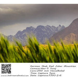
قله جوپار، که به قله سه شاخ بزرگ نیز معروف است، یکی از مرتفعترین و فنیترین قلل ایران است. این قله در رشتهکوه جوپار در استان کرمان قرار دارد و ارتفاع آن به ۴۱۳۵ متر میرسد¹². کوهستان جوپار به دلیل دیوارههای بلند، تیغههای سوزنی شکل، و برفچالهای عظیم، به ویژه در فصل زمستان، یکی از چالشبرانگیزترین مقاصد کوهنوردی در ایران محسوب میشود¹².
شهر جوپار نیز در بخش ماهان شهرستان کرمان واقع شده و به دلیل آب و هوای خوب و طبیعت زیبا، مقصدی محبوب برای گردشگران است
به این عکس امتیاز دهید.
این عکس توسط بهرام عابدینی از تپه ها و طبیعت اطراف این منطقه گرفته شده است. برای خرید این عکس یا عکس های دیگر از طریق وبسایت یا تلفن با ما تماس بگیرید.
Choopar Mountain, also known as Joopar Mountain, is one of the most prominent and challenging peaks in Iran. Located in the southeastern part of Kerman Province, this mountain is part of the Joopar mountain range, which stretches approximately 22 kilometers in length and 10 kilometers in width.
The highest peak in this range, known as the "Three Horns" or "Seh Shakh Bozorg," reaches an elevation of 4,135 meters. The mountain is renowned for its steep cliffs, needle-like ridges, and large snowfields, making it a popular destination for experienced climbers and mountaineers. Even in summer, snow can often be found on its highest peaks.
The area is also rich in biodiversity, with various medicinal plants such as thyme and black cumin, as well as wildlife including wolves, foxes, and mountain goats⁴⁵. The scenic beauty and challenging terrain of Choopar Mountain make it a significant attraction for nature enthusiasts and adventure seekers alike.
Please rate this picture.
This picture is taken by Bahram Abedini. If you want to purchase this picture or any other around this area please contact us through website, email or phone.
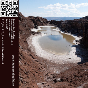
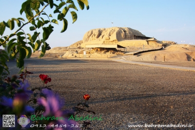
گنبد نمکی قم، که به نام گنبد نمکی طغرود نیز شناخته میشود، یکی از جاذبههای طبیعی و منحصر به فرد استان قم است. این گنبد در ۱۵ کیلومتری جاده قم به سمت جعفریه قرار دارد و به دلیل تقارن و وجود دریاچهای کوچک در دل خود، تنها گنبد نمکی متقارن جهان محسوب میشود.
این گنبد نمکی با قدمتی حدود ۶۰ میلیون سال، از بلورهای نمک به شکل تیغههای کنگرهدار تشکیل شده که مناظر زیبایی را خلق کردهاند. دریاچه نمکی درون گنبد، پس از بارشهای فصلی و تبخیر آبهای شور، به لایههای ضخیمی از نمک تبدیل میشود که تا ارتفاع نیم متر نیز میرسد.
این منطقه به دلیل زیباییهای طبیعی و خواص درمانی آب نمک، مقصدی محبوب برای گردشگران و علاقهمندان به ژئوتوریسم است
به این عکس امتیاز دهید.
این عکس توسط بهرام عابدینی از تپه ها و طبیعت اطراف این منطقه گرفته شده است. برای خرید این عکس یا عکس های دیگر از طریق وبسایت یا تلفن با ما تماس بگیرید.
Gonbad Namaki Ghom, also known as the Qom Salt Dome, is a fascinating natural attraction located about 20 kilometers northwest of Qom city on the Qom-Jaafrieh axis. This salt dome is renowned for its unique geological formations and stunning landscapes, making it one of the largest and most beautiful salt domes in Iran⁴.
The dome, which is around 60 million years old, features impressive salt crystals that form intricate patterns and shapes. During the rainy seasons, a small salt lake forms within the dome, creating a striking contrast with the surrounding arid landscape⁴. This lake, however, is not permanent and often dries up during the hotter months⁴.
Gonbad Namaki Ghom is a popular destination for tourists and geotourism enthusiasts, who visit to admire its natural beauty and explore its therapeutic salt properties⁴.
Please rate this picture.
This picture is taken by Bahram Abedini. If you want to purchase this picture or any other around this area please contact us through website, email or phone.
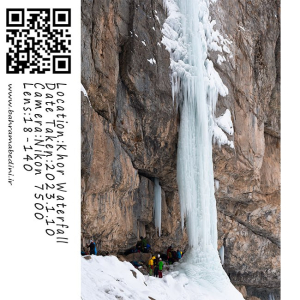
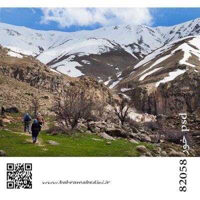
آبشار خور یکی از جاذبههای طبیعی زیبا در روستای خور، ایران است. این آبشار دیدنی به خاطر زیبایی آرامشبخش و سرسبزی اطرافش شناخته شده است. آبشار از صخرههای سنگی به پایین میریزد و به استخری شفاف در پایین میرسد، که محیطی آرام و تازهکننده ایجاد میکند. این منطقه در میان کوهنوردان و علاقهمندان به طبیعت که از مسیرهای دیدنی منتهی به آبشار لذت میبرند، محبوب است. بهترین زمان برای بازدید از این آبشار در فصل بهار و اوایل تابستان است که جریان آب در اوج خود قرار دارد و گیاهان اطراف در حال شکوفهدهی هستند.
به این عکس امتیاز دهید.
این عکس توسط بهرام عابدینی از تپه ها و طبیعت اطراف این منطقه گرفته شده است. برای خرید این عکس یا عکس های دیگر از طریق وبسایت یا تلفن با ما تماس بگیرید.
Khor Waterfall is a stunning natural attraction located in the village of Khor, Iran. This picturesque waterfall is known for its serene beauty and the lush greenery that surrounds it. The waterfall cascades down rocky cliffs into a clear pool below, creating a tranquil and refreshing environment. The area is popular among hikers and nature enthusiasts who enjoy the scenic trails leading to the waterfall. The best time to visit is during the spring and early summer when the water flow is at its peak, and the surrounding flora is in full bloom.
Please rate this picture.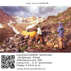
کوه کلجاران و رستم نیشت دو قله برجسته در توده تخت سلیمان در رشتهکوه البرز ایران هستند. کوه کلجاران با ارتفاع تقریبی ۴۴۳۱ متر (۱۴۵۳۷ فوت) به دلیل مسیرهای پیادهروی چالشبرانگیز و درههای مهآلود و سرسبز که تحت تأثیر دریای خزر نزدیک قرار دارند، شناخته شده است. پیادهروی به گردنه کلجاران مناظر خیرهکنندهای از قلهها و درههای اطراف ارائه میدهد.
رستم نیشت با ارتفاع تقریبی ۴۴۲۶ متر (۱۴۵۲۰ فوت)، دارای یک فلات کوچک مثلثی با سه قله نوکتیز و دامنههای شیبدار پوشیده از سنگریزه است که به شدت به دره سهزار میافتند. صعود به رستم نیشت اغلب از روستای ونداربن آغاز میشود و از پناهگاه سرچال عبور میکند، که مناظر خیرهکنندهای از قلههای هفتخان و یخچال هفتخان را ارائه میدهد.
هر دو کوه پیادهرویهای دشوار و مناظر دیدنی ارائه میدهند و مقصدهای پاداشبخش برای کوهنوردان با تجربه هستند.
به این عکس امتیاز دهید.
این عکس توسط بهرام عابدینی از تپه ها و طبیعت اطراف این منطقه گرفته شده است. برای خرید این عکس یا عکس های دیگر از طریق وبسایت یا تلفن با ما تماس بگیرید.
Kaljaran Mountain and Rostam Nisht are two prominent peaks in the Takhte Soleyman Massif of the Alborz mountain range in Iran. Kaljaran Mountain stands at approximately 4,431 meters (14,537 feet) and is known for its challenging hiking routes and lush, fog-filled valleys influenced by the nearby Caspian Sea. The hike to Kaljaran Pass offers stunning views of the surrounding peaks and valleys.
Rostam Nisht, with an elevation of around 4,426 meters (14,520 feet), features a small triangular plateau with three pointy summits and steep scree-covered western slopes. The climb to Rostam Nisht often starts from the village of Vandar Bon and passes through the Sar Chal Shelter, leading to breathtaking views of the Haft Khan Peaks and the Haft Khan Glacier.
Both mountains offer demanding hikes and spectacular scenery, making them rewarding destinations for experienced hikers.
Please rate this picture.
This picture is taken by Bahram Abedini. If you want to purchase this picture or any other around this area please contact us through website, email or phone.
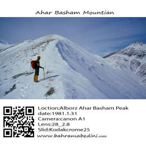
قله آهار بشم با ارتفاع ۳۱۳۰ متر در رشتهکوههای البرز مرکزی و در نزدیکی روستای آهار قرار دارد. مسیر صعود به این قله از روستای آهار آغاز میشود و از میان مناظر طبیعی زیبا و باغهای سرسبز عبور میکند، که آن را به مقصدی محبوب برای کوهنوردان و طبیعتگردان تبدیل کرده است.
به این عکس امتیاز دهید.
این عکس توسط بهرام عابدینی از تپه ها و طبیعت اطراف این منطقه گرفته شده است. برای خرید این عکس یا عکس های دیگر از طریق وبسایت یا تلفن با ما تماس بگیرید.
Ahar Bashm Mountain, also known as Kūh-e Āhār Bashm, is a prominent peak located in Tehran, Iran, standing at an elevation of 3,129 meters (10,266 feet). This mountain is a popular destination for hikers and nature enthusiasts due to its scenic trails and relatively gentle slopes. The hike typically begins from the village of Āhār and passes through lush gardens and alongside a river, leading to a shrine (Imamzadeh) and a picturesque waterfall. Despite the moderate difficulty of the hike, it’s important for hikers to carry sufficient water as there are no natural springs along the route.
Please rate this picture.
This picture is taken by Bahram Abedini. If you want to purchase this picture or any other around this area please contact us through website, email or phone.
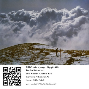
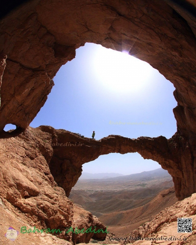
عکسی از قله توچال در سال 1364 در ماه بهمن
مشخصات دوربین و لنز در زیر عکس ذکر شده است.
به این عکس امتیاز دهید.
این عکس توسط بهرام عابدینی از تپه ها و طبیعت اطراف این منطقه گرفته شده است. برای خرید این عکس یا عکس های دیگر از طریق وبسایت یا تلفن با ما تماس بگیرید.
English description:
In 1985, Tochal Mountain in Iran, part of the Alborz range, was a popular destination for its stunning views and rugged terrain. Standing at 3,963 meters, it featured various peaks and trails for hikers and climbers. The Tochal Telecabin, a gondola lift, provided easy access to higher altitudes and the ski resort. The mountain’s proximity to Tehran made it a quick escape for outdoor enthusiasts, with shelters like Shirpala and Siahsang offering rest stops. Overall, Tochal was a cherished natural landmark blending adventure and tranquility.
Please rate this picture.
This picture is taken by Bahram Abedini. If you want to purchase this picture or any other around this area please contact us through website, email or phone.
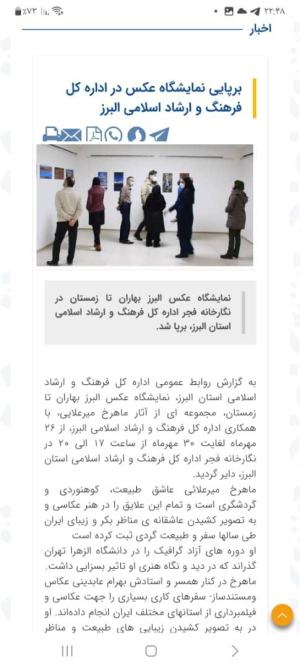
نمایشگاه عکس البرز بهاران تا زمستان در نگارخانه فجر اداره کل فرهنگ و ارشاد اسلامی استان البرز، برپا شد
در این نمایشگاه آثاری منتخب از عکاسی های طبیعت ماهرخ میرعلائی به معرض دید عموم قرار گرفت.
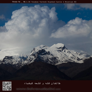
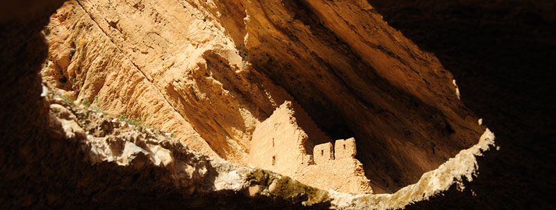
قله ی کیقباد در منطقه ی طالقان
قلعه کیقباد در منتهی الیه جنوب غرب روستای ایگل و در دامنه شرقی ارتفاعاتی که نهایتا به قله توچال منتهی می شود و خانه های ده در دامنه آن واقع شده است و در موقعیت جغرافیایی 35 درجه و 54 دقیقه و 44 ثانیه عرض جغرافیایی و 51 درجه و 29 دقیقه و 2 ثانیه طول جغرافیایی و در ارتفاع 2062 متر از سطح دریا و در جبهه جنوب شرقی و پایین صخره سنگی که در مجاورت ده و خانه های آن قرار دارد واقع شده است.
از قلعه کیقباد هرنج، امروزه جز بقایای دیوارهایی از ملات ساروج، چیزی باقی نمانده و کاملا تخریب شده است.
امروزه و در حال حاضر، بسیاری از بخش های قلعه کیقباد به به کلی نابود شده و حفاریهای غیرمجاز در آن نیز موجب مخدوش شدن چهره اولیه این قلعه زیبا شده است. با این وجود این قلعه هنوز دارای ارزش علمی فرهنگی بالایی می باشد و ثبت و ضبط این قلعه می تواند زمینه را برای مطالعات بیشتر و کاوش علمی در آن فراهم نماید.
برگرفته از وبسایت لوکس ویلا دات آی آر
the mountain of Keyghobad in the region of Taleghan, north of Iran.
Kiqbad Castle is located at the extreme southwest of Eagle village and on the eastern slope of the heights that ultimately leads to Tochal peak and ten houses on its slope and is located at 35 degrees 54 minutes 44 seconds latitude and 51 degrees and 29 minutes and 2 seconds of longitude and is located at an altitude of 2062 meters above sea level and on the southeast front and at the bottom of the rock that is located in the vicinity of ten houses.
Today, there is nothing left of Kiqbad Haranj Castle except for the remains of walls made of Saroj mortar and it has been completely destroyed.
Today and now, many parts of the Qiqbad castle have been completely destroyed and unauthorized excavations have also caused the original appearance of this beautiful castle to be distorted. However, this castle still has a high scientific and cultural value, and the recording of this castle can provide the basis for further studies and scientific research in it.