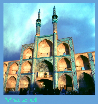
عکس های آثار تاریخی و باستانی ایران
عکس های آثار تاریخی و باستانی ایران
عکس های آثار تاریخی و باستانی ایران
بهرام عابدینی
بهرام عابدینی
بهرام عابدینی
Website Language

")
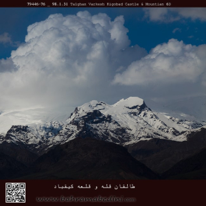
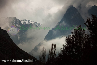
قله ی کیقباد در منطقه ی طالقان
قلعه کیقباد در منتهی الیه جنوب غرب روستای ایگل و در دامنه شرقی ارتفاعاتی که نهایتا به قله توچال منتهی می شود و خانه های ده در دامنه آن واقع شده است و در موقعیت جغرافیایی 35 درجه و 54 دقیقه و 44 ثانیه عرض جغرافیایی و 51 درجه و 29 دقیقه و 2 ثانیه طول جغرافیایی و در ارتفاع 2062 متر از سطح دریا و در جبهه جنوب شرقی و پایین صخره سنگی که در مجاورت ده و خانه های آن قرار دارد واقع شده است.
از قلعه کیقباد هرنج، امروزه جز بقایای دیوارهایی از ملات ساروج، چیزی باقی نمانده و کاملا تخریب شده است.
امروزه و در حال حاضر، بسیاری از بخش های قلعه کیقباد به به کلی نابود شده و حفاریهای غیرمجاز در آن نیز موجب مخدوش شدن چهره اولیه این قلعه زیبا شده است. با این وجود این قلعه هنوز دارای ارزش علمی فرهنگی بالایی می باشد و ثبت و ضبط این قلعه می تواند زمینه را برای مطالعات بیشتر و کاوش علمی در آن فراهم نماید.
برگرفته از وبسایت لوکس ویلا دات آی آر
the mountain of Keyghobad in the region of Taleghan, north of Iran.
Kiqbad Castle is located at the extreme southwest of Eagle village and on the eastern slope of the heights that ultimately leads to Tochal peak and ten houses on its slope and is located at 35 degrees 54 minutes 44 seconds latitude and 51 degrees and 29 minutes and 2 seconds of longitude and is located at an altitude of 2062 meters above sea level and on the southeast front and at the bottom of the rock that is located in the vicinity of ten houses.
Today, there is nothing left of Kiqbad Haranj Castle except for the remains of walls made of Saroj mortar and it has been completely destroyed.
Today and now, many parts of the Qiqbad castle have been completely destroyed and unauthorized excavations have also caused the original appearance of this beautiful castle to be distorted. However, this castle still has a high scientific and cultural value, and the recording of this castle can provide the basis for further studies and scientific research in it.
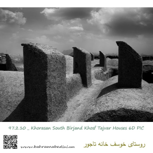
عکس سیاه و سفیدی که مشاهده میکنید در روستای بیرجند گرفته شده و بادگیر های خانه ی تاجور را نشان میدهد که محل میراث فرهنگی فعلی است.
these are the wind catchers on roof tops on an adobe house in the city of Birjand. click on the windcatcher keyworks to see more pictures like this.
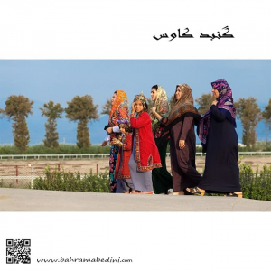
Group of women In local costumes
North Iran , Gonbad Kavoos
گروهی از زنان گنبد کاووس در راه مراسم عروسی
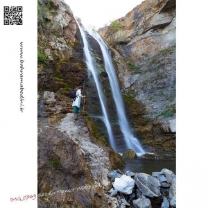
عکسی از آبشار منصور در استان قزوین
Mansoor waterfall in the province of Qazvin
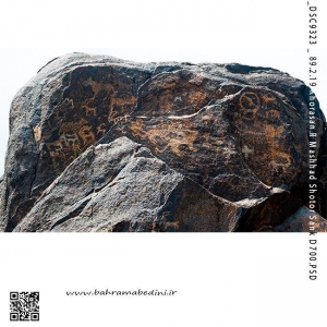
سنگ نگاره شتر سنگ مربوط به دوران پیش از تاریخ ایران باستان تا دورانهای تاریخی پس از اسلام است
اولین نکتهٔ جالبی در ارتباط با این سنگ نگارهها، نوع سنگها (بومهای گرد) و رنگ آنها (قهوهای تیره) بود. اکثر نقوش حکاکی شده بر بومها دارای جهتی رو به جنوب و شرق دارند. همهٔ نکات ذکر شده نشان از هوش و درایت هنرمندان حکاکی را دارد که از هزاران سال پیش با رویکرد لگاریم سنجی یا ریز فرسایش آشنایی داشتهاند، این دانش نظری باعث شده تا آنها خود را روبه بهترین جهت و مناسبترین شیب خلق کنند تا از حدود یازده هزار سال قبل تا کنون این آثار هنری حفظ شوند. بر روی این سنگ نگاره باستانی نقشهای بزکوهی، نقشهای انسان، انسانهای شیر سوار، نقش نمادها و دیگر جانداران موجود میباشند
این اثر باستانی در ۸۰۰ متری جاده مشهد - شاندیز، بخش طرقبه، روستای دهنو، باغ بیلدر واقع شده است
This is Petroglyph of Shotor Sang . Shotor means camel and sang means rock. So shotor sang means camel rock. This is 11 thousands years old. This petroglyph is situated in the city of Mashad in the province of Khorasan in east Iran in the village of Dehno.
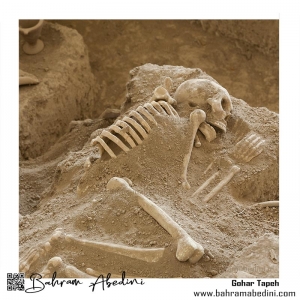
عکسی از گوهر تپه
در منطقه نکاء در استان مازندران
گوهرتپه یکی از استقرارگاههای پیش از تاریخی ایران است که در دوران مس و سنگ (۳۵۰۰ ق. م) شکل گرفتهاست. قرار داشتن این محوطه در حد فاصل درهها و غارهای باستانی همچون غار هوتو، غار کمربند و غار کومیشان اهمیت آن را دو چندان کردهاست.
Gohar Tapeh
Or the Hill of Jewels
location: Neka, Mazandaran, Iran
Gohar Tapeh is 3500 B.C. old and is one of the pre historic habitats of early Iranians who in the age of Iron and copper lived there. This place is located in between valleys and ancient caves like the cave of Hutu and cave of kumishan.
لنجان - بقعه پیربکران 30 کیلومتری اصفهان ثبت تاریخی 101
آرامگاه و رواق و صحن بقعه پیربکران از بناهای قرن هشتم هجری بشمار است، که در دوره اولجایتو ایلخان مغولی بنا نهاده شده است ، مجموعه این بنا که دارای دو تاریخ 703 و 712 هجری قمری است، شامل تزیینات گچبری و کاشیکاری بسیار زیبائی است. خطوط ثلث و کوفی و یک سلسله کتیبه های گچبری اهمیت و جذبه خاصی باین بقعه بخشیده ، این بنا که آرامگاه محمد بن بکران از زهاد قرن هشتم هجری است، مشتمل بر رواق ، صحن ، سردر و مقبره میباشد. نام استاد و نقاش بی نظیر این اثر نفیس و هنری محمد شاه نقاش میباشد ، خلاصه بنای مزبور در شمار شاهکاری از هنرهای تزئینی ایران است.
Lenjan - Pirbakran Tomb 30 km from Isfahan Historical record 101
The tomb, porch and courtyard of the tomb of Pirbakran are among the buildings of the eighth century AH, which was built in the period of Oljaito Ilkhan Mongolian. The third and Kufic lines and a series of bedrock inscriptions give a special importance and charm to this tomb, which is the tomb of Muhammad ibn Bakran from the eighth century AH, and includes a porch, courtyard, entrance and tomb. The name of the unique master and painter of this exquisite and artistic work is Mohammad Shah Shah Naghash, the summary of this building is among the masterpieces of Iranian decorative arts
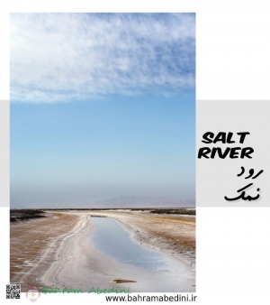
رود نمک و خطوط افق در نزدیکی شهر طبس در خراسان جنوبی
Salt River, near the city of Tabas, in South Khorasan province in Iran
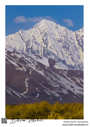
عکس فوق قله ی قالی کوه در شهر الیگودرز را به تصویر میکشد. این کوه به ارتفاع 4100 متر از سطح دریا در استان لرستان واقع است و طبیعت بسیار زیبایی دارد.
Ghali kooh, A mountain in west Iran This snow caped mountain in the mountain series of Zagros is risen up to the sky in west of Iran in the city of Aligoodarz. The whole province of Lorestan is teaming with beautiful pristine nature and high rise mountains ready to be hiked. the height of this mountain is 13451.44 fts.
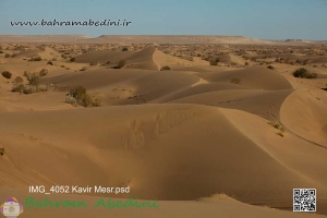
مصر نام روستای کوچکی است که در 55 کیلومتری شهرستان خور از توابع استان اصفهان واقع شده و ۱۸۰ نفر(41 خانوار) جمعیت دارد .مصر در میانه راه دامغان به نائین و اصفهان قرار دارد. این کویر توسط رشته کوههایی از جانب غرب، جنوب غرب و جنوب شرق محاصره میشود که بخشی از سلسله جبال کوههای فلات مرکزی ایران به حساب میآیند. این کویر در گودالهایی طبیعی در کوهپایههای این کوهها، تپههای ماسهای زیبایی را تشکیل داده است.
Messr is the name of a small village in a beautiful desert located 55 kilometers from the city of Khor of Isfahan province and has a population of 180 people (41 households). The desert is surrounded by mountain ranges from the west, southwest and southeast that form part of the mountains of the Central Plateau of Iran. The desert forms beautiful sand dunes in natural pits in the foothills of these mountains.