آخرین عکس های طبیعت و مناظر ایران
بهرام عابدینی
آخرین عکس های طبیعت و مناظر ایران
آخرین عکس های طبیعت و مناظر ایران
بهرام عابدینی
بهرام عابدینی
Website Language

")

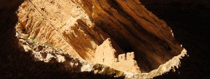
Farsi Description:
آتشکده اسپاخو بنایی تاریخی از دوره ساسانی است که در روستای اسپاخو در استان خراسان شمالی قرار دارد. این آتشکده با معماری سنگی و گنبدی شکل، دارای سه ورودی و ایوانی بلند در ضلع شرقی است. در گذشته برای نیایش زرتشتیان و نگهداری آتش مقدس استفاده میشد. این بنا یکی از قدیمیترین آثار تاریخی منطقه است و در فهرست آثار ملی ایران ثبت شده است.
به این عکس امتیاز دهید.
این عکس توسط بهرام عابدینی از تپه ها و طبیعت اطراف این منطقه گرفته شده است. برای خرید این عکس یا عکس های دیگر از طریق وبسایت یا تلفن با ما تماس بگیرید.
توضیحات انگلیسی:
The Espakho Fire Temple is a historical structure from the Sassanid era, located in the village of Espakho in North Khorasan Province, Iran. Built with stone and featuring a domed roof, the temple has three entrances and a tall eastern portico. It was used by Zoroastrians for worship and to preserve sacred fire. This temple is one of the oldest surviving monuments in the region and is listed as a national heritage site of Iran.
Please rate this picture.
This picture is taken by Bahram Abedini. If you want to purchase this picture or any other around this area please contact us through website, email or phone.
We sell pictures digitally in Large format and internationally through secure paypal payment in the US.
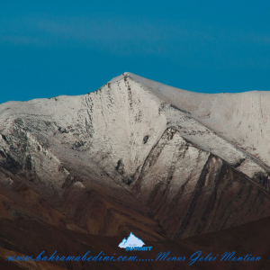
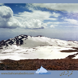
Farsi Description:
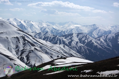
قله منا ر و گلوی به ارتفاع تقریبی سه وهزارو پانصد متر در شمال روستای واریان وجنوب شرقی روستای مورودقرار دارد این دوقله در خطالراس سیاه سنگ منار و گلوی و گلو سربند واقع است راه صعود به قله بیشتر از روستای مورود است آبشار های که از قله ها سرازیر می شود یکی آبشا ر چهار صد تنور در جنوب و آبشار رفک در شمال این کوه قرار دارد.
به این عکس امتیاز دهید.
این عکس توسط بهرام عابدینی از تپه ها و طبیعت اطراف این منطقه گرفته شده است. برای خرید این عکس یا عکس های دیگر از طریق وبسایت یا تلفن با ما تماس بگیرید.
توضیحات انگلیسی:
Please rate this picture.
The peaks of Manar and Golou, with an approximate height of 3,500 meters, are located north of the village of Varyan and southeast of the village of Moroud. These two peaks are situated on the ridge of Siah Sang Manar and Golou and Golou Sarband. The main route to ascend the peaks is from the village of Moroud. The waterfalls that flow from the peaks include the Four Hundred Tanur waterfall in the south and the Rafak waterfall in the north of this mountain."
This picture is taken by Bahram Abedini. If you want to purchase this picture or any other around this area please contact us through website, email or phone.
We sell pictures digitally in Large format and internationally through secure paypal payment in the US.
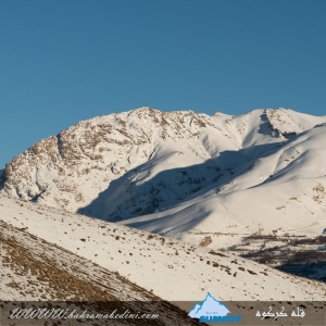
Farsi Description:
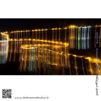
قلهٔ کرکوه با ارتفاع ۳۱۰۰ متر در درهٔ خور و سیجان واقع شده است. این قله با قلههای پهنهحصار و چال ناجی یال مشترک دارد و آبشارهای زیبای پنجهپلنگ و رفک در دامنههای آن قرار گرفتهاند. منطقهٔ کرکوه با طبیعت بکر، پوشش گیاهی متنوع و چشماندازهای کوهستانی، یکی از مقاصد محبوب کوهنوردان و طبیعتگردان در نزدیکی تهران به شمار میرود.
به این عکس امتیاز دهید.
این عکس توسط بهرام عابدینی از تپه ها و طبیعت اطراف این منطقه گرفته شده است. برای خرید این عکس یا عکس های دیگر از طریق وبسایت یا تلفن با ما تماس بگیرید.
توضیحات انگلیسی:
Mount Karkouh, standing at an elevation of 3,100 meters, is located in the Khur and Sijan valley. It shares a ridge with the peaks of Pahneh Hisar and Chal Naji, and the beautiful waterfalls of Panjeh Palang and Rafak lie at its base. The Karkouh region, with its pristine nature, diverse vegetation, and stunning mountain landscapes, is a popular destination for hikers and nature enthusiasts near Tehran.
Please rate this picture.
This picture is taken by Bahram Abedini. If you want to purchase this picture or any other around this area please contact us through website, email or phone.
We sell pictures digitally in Large format and internationally through secure paypal payment in the US.
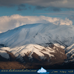
Farsi Description:
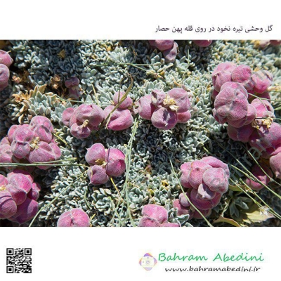
کوه پهنه حصار یک قله برجسته در کوههای البرز مرکزی در شمال ایران، نزدیک روستای سنگان بالا است. این کوه به خاطر مسیرهای دیدنی، مناظر متنوع و تنوع زیستی غنی خود شناخته شده است. این منطقه شامل آبشار چشمگیر سنگان نیز میشود که آن را به مقصدی محبوب برای کوهنوردان و علاقهمندان به طبیعت تبدیل کرده است.
به این عکس امتیاز دهید.
این عکس توسط بهرام عابدینی از تپه ها و طبیعت اطراف این منطقه گرفته شده است. برای خرید این عکس یا عکس های دیگر از طریق وبسایت یا تلفن با ما تماس بگیرید.
توضیحات انگلیسی:
The Mountain of Pahne Hesar is a prominent peak in the Central Alborz Mountains of northern Iran, near the village of Sangan Bala. It's known for its scenic trails, diverse landscapes, and rich biodiversity. The area includes the impressive Sangan Waterfall, making it a popular destination for hikers and nature enthusiasts.
Please rate this picture.
This picture is taken by Bahram Abedini. If you want to purchase this picture or any other around this area please contact us through website, email or phone.
We sell pictures digitally in Large format and internationally through secure paypal payment in the US.
Farsi Description:
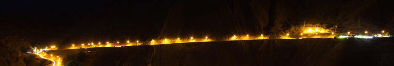
قله چشمه شاهی به ارتفاع سه هزارو دویست و هشتاد متر این کوه در شمال غرب تهران واقع شده است. در شرق این قله روستای سنگان، در جنوب شرقی آن روستای کشار علیا، در غرب روستای چاران و آبشار زیبای چاران و در شمال غربی آن روستای خور و در شمال قله پهنه حصار واقع شده است که در حقیقت با قله پهنه حصار و قله بارو یال مشترک دارد قله چشمه شاهی در نقشه ها جزو استان تهران میباشد ولی جزو حوزه آبریز رودخانه کرج هست آبشارهای که از این کوه به پائین می ریزد عبارت از آبشار خور -_ چاران _ کندور _ ده سر _ سکوت یزدان _ سر تنگه _ آرزوها _
به این عکس امتیاز دهید.
این عکس توسط بهرام عابدینی از تپه ها و طبیعت اطراف این منطقه گرفته شده است. برای خرید این عکس یا عکس های دیگر از طریق وبسایت یا تلفن با ما تماس بگیرید.
توضیحات انگلیسی:
Cheshmeh Shahi Peak, with an elevation of 3,280 meters, is located in the northwest of Tehran. To the east of this peak is the village of Sangan, to the southeast is the village of Keshar Aliya, to the west is the village of Charan and the beautiful Charan Waterfall, and to the northwest is the village of Khor. To the north of the peak is Pahneh Hesar, which shares a ridge with Baro Peak. Although Cheshmeh Shahi Peak is marked as part of Tehran province on maps, it belongs to the Karaj River watershed. The waterfalls descending from this mountain include Khor Waterfall, Charan Waterfall, Kondor Waterfall, Deh Sar Waterfall, Sokut Yazdan Waterfall, Sar Tange Waterfall, and Arezuha Waterfall.
Please rate this picture.
This picture is taken by Bahram Abedini. If you want to purchase this picture or any other around this area please contact us through website, email or phone.
We sell pictures digitally in Large format and internationally through secure paypal payment in the US.
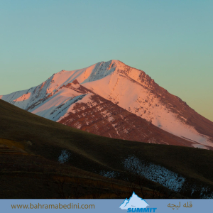
Farsi Description:
قله لیچه به ارتفاع 2900 در استان البرز در شرق روستای کندور و در غرب روستای واریش تهران قرار دارد مسیرهای صعود روستای کندور و روستای واریش میباشد لیچه همجوار با کوه چشمه شاهی ودر ادامه یال به قله لیز و لیزان متصل می شود ارتفاع قله 2900 متر واین عکس از جاده قدیم کندور زیر قله پورا گرفته شده
به این عکس امتیاز دهید.
این عکس توسط بهرام عابدینی از تپه ها و طبیعت اطراف این منطقه گرفته شده است. برای خرید این عکس یا عکس های دیگر از طریق وبسایت یا تلفن با ما تماس بگیرید.
توضیحات انگلیسی:
"Liche Peak, with an elevation of 2900 meters, is located in Alborz Province, east of Kondor village and west of Varish village in Tehran. The ascent routes are from Kondor village and Varish village. Liche is adjacent to Cheshmeh Shahi mountain and continues along the ridge to connect to Liz and Lizan peaks. The elevation of the peak is 2900 meters, and this photo was taken from the old Kondor road below Pura Peak."
Please rate this picture.
This picture is taken by Bahram Abedini. If you want to purchase this picture or any other around this area please contact us through website, email or phone.
We sell pictures digitally in Large format and internationally through secure paypal payment in the US.

Farsi Description:
آبشار چم چیت، که به نام آبشار آبگرمه نیز شناخته میشود، یکی از جاذبههای طبیعی زیبا در استان لرستان است. این آبشار در نزدیکی روستای چم چیت و در مسیر رودخانه سزار قرار دارد.
آبشار چم چیت با ارتفاع بیش از ۲۰ متر و عرض تاج ۱۰ متر، در میان پوششهای گیاهی متراکم و طبیعت بکر منطقه جاری است. این آبشار به دلیل نزدیکی به آبشار مشهور بیشه کمتر شناخته شده است، اما زیبایی خاص خود را دارد و در تمام فصول سال جذابیتهای ویژهای ارائه میدهد.
برای رسیدن به این آبشار، میتوانید از مسیرهای ریلی و آسفالته استفاده کنید. مسیر ریلی از راهآهن تهران-خوزستان و بین ایستگاههای قارون و بیشه میگذرد.
به این عکس امتیاز دهید.
این عکس توسط بهرام عابدینی از تپه ها و طبیعت اطراف این منطقه گرفته شده است. برای خرید این عکس یا عکس های دیگر از طریق وبسایت یا تلفن با ما تماس بگیرید.
توضیحات انگلیسی:
Cham Chit Waterfall, also known as Abgarmeh Waterfall, is one of the beautiful natural attractions in Lorestan Province. This waterfall is located near the village of Cham Chit and along the Sezar River.
Cham Chit Waterfall, with a height of over 20 meters and a crown width of 10 meters, flows amidst dense vegetation and pristine nature. Due to its proximity to the famous Bisheh Waterfall, it is less known but has its own unique beauty and offers special attractions in all seasons.
To reach this waterfall, you can use both rail and asphalt routes. The rail route passes through the Tehran-Khuzestan railway and between the stations of Qarun and Bisheh.
Please rate this picture.
This picture is taken by Bahram Abedini. If you want to purchase this picture or any other around this area please contact us through website, email or phone.
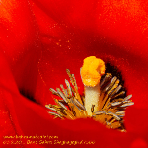
Farsi Description:
گل شقایق، با رنگ قرمز آتشین و دلربای خود، همچون شعلهای از عشق و زندگی در دشتهای بانو صحرا میدرخشد. این گلهای زیبا در فصل بهار و تابستان، همچون نگینهایی درخشان بر دامان طبیعت این روستای خوش آب و هوا مینشینند و منظرهای رؤیایی و دلانگیز را به ارمغان میآورند.
بانو صحرا، با طبیعت بکر و مناظر دیدنیاش، میزبان این گلهای شگفتانگیز است که هر ساله با شکوفایی خود، جانی تازه به این منطقه میبخشند. شقایقها، با زیبایی بینظیرشان، نه تنها چشمها را مسحور میکنند، بلکه دلها را نیز به تپش میاندازند و یادآور عشق و شهامت در فرهنگ و ادبیات فارسی هستند.
این گلهای زیبا، همچون نگهبانان طبیعت، در دشتها و کوهپایههای بانو صحرا میرویند و با هر نسیم بهاری، قصهای از عشق و زندگی را در گوش طبیعت زمزمه میکنند.
به این عکس امتیاز دهید.
این عکس توسط بهرام عابدینی از تپه ها و طبیعت اطراف این منطقه گرفته شده است. برای خرید این عکس یا عکس های دیگر از طریق وبسایت یا تلفن با ما تماس بگیرید.
اگر ویدئوی دشت شقایق رو ندیده اید ، حتما اینجا ببینید:
https://www.bahramabedini.com/en/video/poppies
توضیحات انگلیسی:
The poppy flower, with its fiery red and captivating hue, shines like a flame of love and life in the fields of Bano Sahara. These beautiful flowers bloom in spring and summer, adorning the pristine nature of this picturesque village and creating a dreamy and enchanting landscape.
Bano Sahara, with its unspoiled nature and scenic views, hosts these magnificent flowers that breathe new life into the region each year with their blossoming. The poppies, with their unparalleled beauty, not only captivate the eyes but also stir the hearts, reminding us of love and bravery in Persian culture and literature.
These stunning flowers, like guardians of nature, grow in the fields and foothills of Bano Sahara, whispering tales of love and life to the nature with every spring breeze.
Please rate this picture.
This picture is taken by Bahram Abedini. If you want to purchase this picture or any other around this area please contact us through website, email or phone.
you can also view the video documentary of the poppy fields here by Bahram Abedini:
https://www.bahramabedini.com/en/video/poppies

Farsi Description:
کویر لوت یکی از شگفتانگیزترین مناطق طبیعی ایران است و در فروردین 1403 میزبان گردشگران و طبیعتدوستان خواهد بود. جاده شهداد به نهبندان، که از دل این کویر میگذرد، یکی از مسیرهای محبوب برای سفر به این منطقه است.
در این سفر، میتوانید از کلوتهای شهداد بازدید کنید. کلوتها، برجستگیهای شنی عظیمی هستند که در اثر فرسایش باد و آب به وجود آمدهاند و یکی از زیباترین مناظر طبیعی ایران را تشکیل میدهند. این منطقه به دلیل زیبایی بینظیر و شرایط خاص جغرافیایی، در فهرست آثار ملی ایران و میراث جهانی یونسکو به ثبت رسیده است.
در طول این سفر، میتوانید از جاذبههای تاریخی منطقه شهداد نیز بازدید کنید و از نخلستانها و رود شور که تنها رود دائمی در اعماق کویر لوت است، دیدن کنید. همچنین، تجربه شبنشینی و رصد آسمان پرستاره کویر و بازدید از آبشار کشیت، از دیگر جاذبههای این سفر خواهد بود.
به این عکس امتیاز دهید.
این عکس توسط بهرام عابدینی از تپه ها و طبیعت اطراف این منطقه گرفته شده است. برای خرید این عکس یا عکس های دیگر از طریق وبسایت یا تلفن با ما تماس بگیرید.
توضیحات انگلیسی:
The Lut Desert, one of Iran's most astonishing natural areas, will welcome tourists and nature enthusiasts in April 2024. The road from Shahdad to Nehbandan, which passes through this desert, is a popular route for traveling to this region.
During this trip, you can visit the Shahdad Kaluts. These massive sand formations, created by wind and water erosion, are among the most beautiful natural landscapes in Iran. Due to its unique beauty and geographical conditions, this area is listed as a national heritage site in Iran and a UNESCO World Heritage site.
Throughout this journey, you can also explore the historical attractions of the Shahdad region, visit the palm groves, and see the Shur River, the only permanent river in the depths of the Lut Desert. Additionally, experiencing a night under the starry desert sky and visiting the Keshit Waterfall are other highlights of this trip.
Please rate this picture.
This picture is taken by Bahram Abedini. If you want to purchase this picture or any other around this area please contact us through website, email or phone.

Farsi Description:
قلعه شاه دژ در نهبندان و قلعه کهنه سربیشه هر دو از آثار تاریخی مهم استان خراسان جنوبی هستند. قلعه شاه دژ به دوره سلجوقیان بازمیگردد و در ۶ کیلومتری شرق نهبندان واقع شده است. قلعه کهنه سربیشه نیز به دورههای صفویه و قاجاریه تعلق دارد و در مرکز شهر سربیشه قرار دارد.
به این عکس امتیاز دهید.
این عکس توسط بهرام عابدینی از تپه ها و طبیعت اطراف این منطقه گرفته شده است. برای خرید این عکس یا عکس های دیگر از طریق وبسایت یا تلفن با ما تماس بگیرید.
توضیحات انگلیسی:
Shah Dezh Castle in Nehbandan and Kohneh Castle in Sarbisheh are both significant historical sites in South Khorasan Province, Iran. Shah Dezh Castle dates back to the Seljuk period and is located 6 kilometers east of Nehbandan. Kohneh Castle, on the other hand, belongs to the Safavid and Qajar periods and is situated in the center of Sarbisheh.
Please rate this picture.
This picture is taken by Bahram Abedini. If you want to purchase this picture or any other around this area please contact us through website, email or phone.