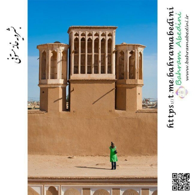
آخرین عکس های طبیعت و مناظر ایران
بهرام عابدینی
آخرین عکس های طبیعت و مناظر ایران
آخرین عکس های طبیعت و مناظر ایران
بهرام عابدینی
بهرام عابدینی
Website Language

")

Farsi Description:
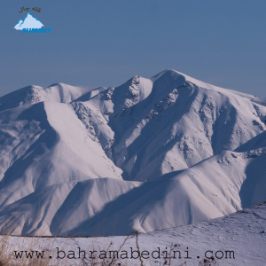
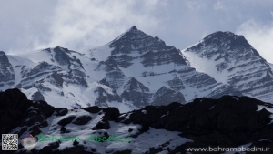
قله چال یکی از قلههای زیبای البرز مرکزی است که با ارتفاع ۲۹۱۸ متر در شمال روستای کندور و جنوب روستای چاران قرار دارد. این قله در خط الراس قله پورا به پهنه حصار واقع شده است. مسیرهای معمول صعود به قله چال شامل روستای چاران، ابهرک، سرزیارت و کندور میباشد.
این منطقه با طبیعت بکر و چشماندازهای خیرهکنندهاش، مقصدی محبوب برای کوهنوردان و طبیعتگردان است. عکسهایی که از روی قله پیله گرفته شدهاند، زیباییهای این منطقه را به خوبی نشان میدهند.
به این عکس امتیاز دهید.
این عکس توسط بهرام عابدینی از تپه ها و طبیعت اطراف این منطقه گرفته شده است. برای خرید این عکس یا عکس های دیگر از طریق وبسایت یا تلفن با ما تماس بگیرید.
توضیحات انگلیسی:
Chal Peak is one of the beautiful peaks of the Central Alborz range, standing at an elevation of 2,918 meters. It is located north of the village of Kondor and south of the village of Charan, along the ridge from Pura Peak to Pahneh Hesar. The common routes for ascending Chal Peak include Charan, Abharak, Sarziarat, and Kondor.
This area is a popular destination for hikers and nature enthusiasts due to its pristine nature and stunning landscapes. Photos taken from the summit of Pileh Peak showcase the beauty of this region.
Please rate this picture.
This picture is taken by Bahram Abedini. If you want to purchase this picture or any other around this area please contact us through website, email or phone.
We sell pictures digitally in Large format and internationally through secure paypal payment in the US.
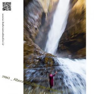
Farsi Description:
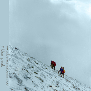
قله هفت خوان یکی از قلل زیبای رشتهکوه البرز غربی است که در نزدیکی روستای سپهسالار قرار دارد و ارتفاع آن به ۳۹۷۰ متر میرسد. در زمستان سال ۱۳۵۹، صعود به این قله به دلیل شرایط سخت آب و هوایی و برف سنگین، چالشی بزرگ برای کوهنوردان بود.
در آن سال، گروهی از کوهنوردان با تجهیزات محدود و بدون امکانات پیشرفته امروزی، تصمیم به صعود به قله هفت خوان گرفتند. مسیر صعود از روستای سپهسالار آغاز شد و کوهنوردان با عبور از یال جنوبی و گردنه خرگوش، به سمت قله حرکت کردند. شرایط سخت زمستانی، از جمله برف سنگین و بادهای شدید، این صعود را بسیار دشوار کرد.
با وجود این چالشها، کوهنوردان با تلاش و پشتکار فراوان توانستند به قله برسند و این صعود به عنوان یکی از دستاوردهای مهم کوهنوردی در آن زمان به شمار میرفت. این صعود نشاندهنده اراده و عزم راسخ کوهنوردان در مواجهه با شرایط سخت طبیعی بود.
به این عکس امتیاز دهید.
این عکس توسط بهرام عابدینی از تپه ها و طبیعت اطراف این منطقه گرفته شده است. برای خرید این عکس یا عکس های دیگر از طریق وبسایت یا تلفن با ما تماس بگیرید.
توضیحات انگلیسی:
Mount Haft Khān is one of the beautiful peaks of the western Alborz mountain range, located near the village of Sepahsalar, with an elevation of 3,970 meters (13,024.93 feet.). In the winter of 1980, climbing this peak was a significant challenge for mountaineers due to harsh weather conditions and heavy snowfall.
That year, a group of mountaineers, with limited equipment and without the advanced facilities available today, decided to climb Mount Haft Khān. The ascent route started from the village of Sepahsalar, and the climbers moved towards the peak by passing through the southern ridge and Kharghosh Pass. The harsh winter conditions, including heavy snow and strong winds, made this climb very difficult.
Despite these challenges, the mountaineers, with great effort and perseverance, managed to reach the summit. This climb was considered one of the significant achievements in mountaineering at that time. It demonstrated the determination and strong will of mountaineers in facing tough natural conditions.
Please rate this picture.
This picture is taken by Bahram Abedini. If you want to purchase this picture or any other around this area please contact us through website, email or phone.

Farsi Description:
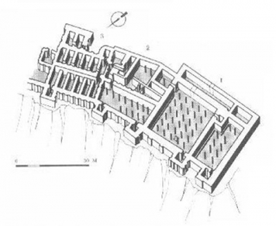
گورستان مجومبار در شبستر، آذربایجان شرقی، ایران، از نظر تاریخی اهمیت زیادی دارد و میراث ارمنی روستا را منعکس میکند. این مکان شامل کلیسای سنت هریپسیمه است که به قرون 9 تا 13 میلادی بازمیگردد و بینشهایی در مورد زندگی و سنتهای جامعه ارمنی که زمانی در این منطقه رونق داشتند، ارائه میدهد. سنگقبرها و کتیبههای گورستان، یاد و خاطره این جامعه را حفظ میکنند.
به این عکس امتیاز دهید.
این عکس توسط بهرام عابدینی از تپه ها و طبیعت اطراف این منطقه گرفته شده است. برای خرید این عکس یا عکس های دیگر از طریق وبسایت یا تلفن با ما تماس بگیرید.
توضیحات انگلیسی:
Mujumbar Cemetery in Shabestar, East Azerbaijan, Iran, is historically significant, reflecting the village’s Armenian heritage. It features the Saint Hripsime Church, dating from the 9th to 13th centuries, and offers insights into the lives and traditions of the Armenian community that once thrived there. The cemetery’s tombstones and inscriptions preserve the memory of this community.
Please rate this picture.
This picture is taken by Bahram Abedini. If you want to purchase this picture or any other around this area please contact us through website, email or phone.
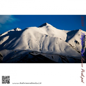
Shah Karam mountain
in the region of Taleghan, north central Iran
طالقان خچیره قله شاه کرم
عظمت و بزرگی کوه های ایران بسیار چشمگیر و زیبا هست و برف این زیبایی را دو چندان میکند. طالقان جزء روستاهایی هست که دور تا دور آن را کوه محاصره کرده و منطقه کوهستانی زیبایی رو به وجود آورده است.
برای خرید این عکس یا دیگر عکس های با ما تماس بگیرید.
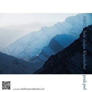
یال قله خونکهار
رشته کوه البرز
KhonKahar mountain
Alborz mountain ranges
North of Iran
آبشار هفت چشمه استان البرز عکسبرداری به طریق زومینگ
Haft Cheshme waterfall
(haft= seven , cheshme= stream)
so it will be translated as seven stream waterfall.
North of Iran in the province of Alborz
Zooming shot
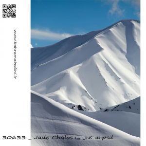
كوههاى پوشده از برف در شمال ايران
قله كلاش ویا در البرز مرکزی به ارتفاع 3900متر
در زبان مازني كلاش به معني عنكبوت و ويا به معني رشته نخ ميباشد
Kalash Viya summit of Alborz mountain series
قله های شاه البرز که در شمال ایران قرار دارد شامل 5 قله میباشد که از فصل زمستان تا بعد از بهار همچنان پوشیده از برف است. رگه های صخره ای به این کوه در زمستان همراه با برف ابهت بسیاری میبخشد که در عکس فوق قابل مشاهده است.
The 5 peaks of Shah-Alborz or (King of Alborz) are situated in the northern part of Iran where the Alborz mountain series are. The boulder stony mountain and the snow make these peaks a very spectacular place to take pictures.
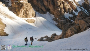
عکس فوق مربوط به صعود قله ی ناز و میشینه نو میباشد که در اویل فصل بهار گرفته شده است. در طول زمستان دره ی فوق که به قله ی ناز منتهی میشود کاملاً پوشیده از برف است و به صورت کامل راه مسدود میشود اما در بهار با آب شدن برف های میتوان از روی یخچال های برفی به سمت قله صعود کرد.
Above is a picture of the Hiking of the Mountain of Naaz and Mishine no peaks, taken in early spring. During the winter, the valley that leads to the summit is completely snow-covered and completely blocked off, but in the spring with snow melting it can be climbed to the summit through snow-covered glaciers.
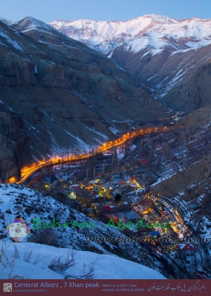
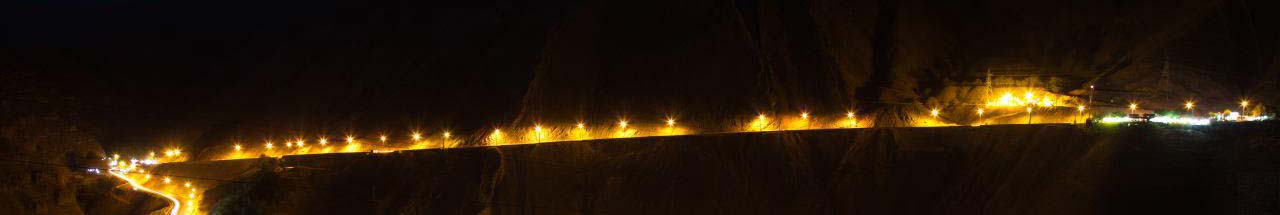
جاده های پرپیچ خم و درخشان چالوس در پل خواب با کوه های هفت خان در پس زمینه.
این عکس اخیراً به صورت چاپی به خانم مولاپناه فروخته شده است.
A photo of Iran's beautiful swinging glowing roads in chaloos at dusk with the summit of Haft-Khan in the background.
This photo is sold in print to Ms. MolaPanah. To buy more pictures like this please call me.